中华人民共和国福建海事局
VTS服务指南
FUJIAN MARITIME SAFETY ADMINISTRATION OF THE PEOPLE’S REPUBLIC OF CHINA VESSEL TRAFFIC SERVICES GUIDE
中华人民共和国福建海事局
FUJIAN MARITIME SAFETY ADMINISTRATION
OF THE PEOPLE’S REPUBLIC OF CHINA
目 录
CONTENTS
前 言
PREFACE
本指南依据《中华人民共和国船舶交通管理系统安全监督管理规则》、《中华人民共和国福建海事局船舶交通管理系统安全监督管理实施细则》等编制,旨在向用户简明介绍中华人民共和国福建海事局船舶交通管理系统(以下简称福建VTS)概况、所属各船舶交通管理服务中心(以下简称交管中心)有关船舶交通管理与服务方面的要求,以及用户需要了解的通航环境情况,以增进交管中心与用户之间的理解和合作,促进船舶航行安全,提高交通效率,保护水域环境。
福建VTS按照其覆盖区域分为福建沿海VTS和福建港口VTS。其中,福建沿海VTS划分为五个VTS分区,交管中心在沿海VTS区域内仅为船舶提供信息服务,在发生海上应急事件或者必要时对船舶交通秩序进行组织与协调。福建港口VTS由宁德、福州、莆田、泉州、厦门和漳州VTS区域组成,交管中心在港口VTS区域内可提供信息服务、助航服务、交通组织服务和支持联合行动。
This guide is compiled and based on the Safety Management Regulations of Vessel Traffic Service of the P.R.C. and the Safety Management Regulations of Vessel Traffic Service of the Fujian Maritime Safety Administration of the P.R.C..The guide is published in order to provide the users with a brief introduction to the Fujian Maritime Safety Administration of P.R.C.Vessel Traffic Service System (hereinafter referred to as Fujian VTS)and the requirement of Vessel Traffic Service Centers of Fujian Maritime Safety Administration (hereinafter referred to as VTS Center) ,so as to promote the understanding and cooperation between VTS Centers and users, to improve the safety and efficiency of navigation and to protect the marine environment.
According to the coverage area, Fujian VTS is divided into Fujian Coastal VTS and Fujian Port VTS. Fujian Coastal VTS is divided into 5 Sectors, VTS centers provide information service for vessels only, organize and coordinate vessel traffic in case of maritime emergency or when necessary in Fujian Coastal VTS area. Fujian Port VTS now includes Ningde, Fuzhou,Putian, Quanzhou, Xiamen and Zhangzhou VTS area, VTS centers provide information service, navigational assistance service, traffic organization service and allied services in Fujian Port VTS area.
沿海VTS服务指南
一、VHF程序
(一)区域范围
福建沿海VTS区域是指由以下七点所围成的、港口水域除外的福建沿海水域。
1.27°10′06″N/120°25′54″E;
2.27°00′00″N/120°47′20″E;
3.26°30′00″N/120°21′00″E;
4.25°21′16″N/120°15′00″E;
5.23°30′00″N/117°55′32″E;
6.23°30′00″N/117°14′00″E;
7.23°36′12″N/117°14′00″E。
(二)VHF工作频道
福建沿海VTS区域由以下四条界线自北向南划分为沿海第Ⅰ区、第Ⅱ区、第Ⅲ区、第Ⅳ区和第Ⅴ区共五个分区。
1.由1.26°30′00″N/120°03′15″E和26°30′00″N/120°21′00″E两点组成的连线。
2.由25°12′00″N/119°18′00″E和25°12′00″N/120°03′22″E两点组成的连线。
3.由24°30′50″N/118°34′15″E和24°30′50″N/119°11′46″E两点组成的连线。
4.由24°N/117°49′30″E和24°N/118°32′42″E两点组成的连线。
各分区及VHF工作频道如下:
分区 工作频道
第Ⅰ区 VHF CH09呼叫宁德交管中心
第Ⅱ区 VHF CH12呼叫福州交管中心
第Ⅲ区 VHF CH69呼叫泉州交管中心
第Ⅳ区 VHF CH67呼叫厦门交管中心
第Ⅴ区 VHF CH13呼叫漳州交管中心
(三)福建沿海VTS区域示意图
| 中国 | 宁德、福州、泉州、厦门和漳州交管中心 | 沿海VTS区域 | 版本号
第四版 |
修正日期
2021年7月 |

本图不可用于航海
二、船舶报告
(一)适用船舶
按照有关国际公约和(或)国内规范规定应当配备通信设备并能够在规定的VHF频道上通讯的船舶。
(二)紧急和异常情况报告
1.报告时机:
(1)交通事故、污染事故、人员意外、保安事件以及其他影响航行安全的紧急情况;
(2)助航标志或者导航设施移位、灭失、损坏、异常;
(3)有碍航行安全的障碍物、漂浮物以及其他妨碍航行安全的异常情况。
2.报告方式:
第Ⅰ区 VHF CH09呼叫宁德交管中心
第Ⅱ区 VHF CH12呼叫福州交管中心
第Ⅲ区 VHF CH69呼叫泉州交管中心
第Ⅳ区 VHF CH67呼叫厦门交管中心
第Ⅴ区 VHF CH13呼叫漳州交管中心
3.报告内容:船名、国籍、时间、地点、事件经过(或紧急异常情况)、请求以及交管中心要求的其他情况。
三、船舶交通服务
交管中心在沿海VTS区域内仅为船舶提供信息服务,在发生海上应急事件或者必要时对船舶交通秩序进行组织与协调。
四、其他信息
(一)当地海事局机构和港口的特别规定
《中华人民共和国福建海事局船舶交通管理系统安全监督管理实施细则》
五、获取信息途径
(一)相关信息发布网站网址
1.中华人民共和国海事局: http://www.msa.gov.cn
2.福建海事局:http://www.fj.msa.gov.cn
(二)当地海事机构联系方式
1.宁德海事局交管中心
邮政编号:352100
通信地址:宁德市蕉城南路121号
联系电话:+86-593-2969113
图文传真:+86-593-2969115
2.福州海事局交管中心
邮政编号:350015
通信地址:福州市马尾区港口路35号
联系电话:+86-591-83684018
图文传真:+86-591-83985000
3.泉州海事局交管中心
邮政编码:362200
通信地址:泉州市晋江泉安南路海事大厦
联系电话:+86-595-22565013
图文传真:+86-595-28080847
4.厦门海事局交管中心
邮政编码:361026
通信地址:厦门市海沧区海沧大道19号
联系电话:0592-6895123
图文传真:0592-6895262
5.漳州海事局交管中心
邮政编码:363105
通信地址:漳州市招商局经济技术开发区招商大道77号
联系电话:+86-596-6856830
图文传真:+86-596-6856655
Fujian coastal Vessel Traffic Services Guide
- VHF Procedures
1.1 VTS area
Fujian coastal water area is bounded by the following seven points, except that area of ports:
(1)27°10′06″N/120°25′54″E;
(2)27°00′00″N/120°47′20″E;
(3)26°30′00″N/120°21′00″E;
(4)25°21′16″N/120°15′00″E;
(5)23°30′00″N/117°55′32″E;
(6)23°30′00″N/117°14′00″E;
(7)23°36′12″N/117°14′00″E。
1.2 VHF channel
Fujian coastal VTS area is divided into five sectors from north to south by the following four boundaries:
(1)The line joining 26°30′00″N/120°03′15″ and 26°30′00″N/120°21′00″E.
(2)The line joining 25°12′00″N/119°18′00″E and 25°12′00″N/120°03′22″E.
(3)The line joining 24°30′50″N/118°34′15″E and 24°30′50″N/119°11′46″E.
(4)The line joining 24°00′00″N/117°49′30″E and 24°00′00″N/118°32′42″E.
The sectors and VHF working channels are as follows:
Sector VHF Working channel
Sector I VHF CH09(call: Ningde VTS)
Sector Ⅱ VHF CH12(call: Fuzhou VTS)
Sector Ⅲ VHF CH69(call: Quanzhou VTS)
Sector Ⅳ VHF CH67(call: Xiamen VTS)
Sector Ⅴ VHF CH13(call: Zhangzhou VTS)
1.3 VTS plans
| CHINA | NINGDE,FUZHOU,QUANZHOU,XIAMEN,
ZHANGZHOU VTS CENTER |
COASTAL
VTS AREA |
EDITION
No.04 |
REVISION DATE
JULY 2021 |

Not to be used for navigation
- Reports
2.1 Applicability:
Vessels should be equipped with the communication equipment and capable of communicating on the specified VHF channel in accordance with relevant international conventions and/or national rules and regulations.
2.2 Emergency and Abnormality Report
WHEN:
(1)Being involved in traffic accident and pollution
incident,person contretemps,security event or any other emergent situations which may affect navigational safety;
(2)Finding aids to navigation or navigational facilities
off-position, missing, damaged or abnormal;
(3)Finding obstacles, floating objects or any other
abnormal situation which may affect navigational safety.
VIA:
Sector I VHF CH09(call: Ningde VTS)
Sector Ⅱ VHF CH12(call: Fuzhou VTS)
Sector Ⅲ VHF CH69(call: Quanzhou VTS)
Sector Ⅳ VHF CH67(call: Xiamen VTS)
Sector Ⅴ VHF CH13(call: Zhangzhou VTS)
GIVING:
1.Ship′s name; 2.Nationality; 3.Time; 4. Position;
5.Process of the accident (Full details of emergency or abnormal situation); 6.Request; 7.Other information required by the VTS center.
- Vessel Traffic Services
VTS centers provide information service for vessels only, organize and coordinate vessel traffic in case of maritime emergency or when necessary.
- Additional Information
4.1 Special provisions of local Maritime Safety Administration:
The Detailed Rules for the Implementation of Safety Supervision and Management of Vessel Traffic Services of Fujian Maritime Safety Administration of the P.R.C..
- Information Inquiry
5.1. Address of websites publishing related information:
(1)CHINA MSA :http://www.msa.gov.cn
(2)Fujian MSA : http://www.fjmsa.gov.cn
5.2.Contact details of local Maritime Safety Administration:
(1) Ningde VTS center
Postal Code: 352100
Address: No.121 Jiaocheng South Road, Ningde ,China.
Tel: +86-593-2969113
Fax: +86-593-2969115
(2) Fuzhou VTS Center:
Post Code:350015
Office Add:35 Gangkou Road, Mawei District, Fuzhou, China
Tel:+86-591-83684018
Fax:+86-591-83985000
(3) Quanzhou VTS Center:
Post Code:362200
Office Add:Maritime Tower, Quanan South Road, Jinjiang, Quanzhou, China
Tel:+86-595-22565013
Fax:+86-595-28080847
(4) Xiamen VTS Center:
Post Code:361026
Office Add:No.19 Haicang Avenue, Haicang District, Xiamen, China
Tel:+86-592-6895123
Fax:+86-592-6895262
(5) Zhanzhou VTS Center:
Post Code:363105
Office Add:77 Zhaoshang Avenue, Zhangzhou , China
Tel:+86-596-6856830
Fax:+86-596-6856655
宁德VTS服务指南
一、VHF程序
(一)区域范围
宁德VTS区域是指由宁德VTS报告线、东线、北线以及港内岸线所围成的水域。
东线:由26°39′05″N/119°51′38″E和26°36′02″N/119°51′44″E两点组成的连线。
北线:由26°42′31″N/119°43′42″E和26°41′51″N/119°47′25″E两点组成的连线。
(二)船舶报告线(点)位置
宁德VTS报告线:由26°31′12″N/119°50′17″E和26°29′33″N/119°48′17″E两点组成的连线。
(三)VHF工作频道
宁德VTS工作频道为VHF CH09,船舶应呼叫宁德交管中心,并必须在VHF09频道上保持守听。
(四)VTS区域示意图
| 中国 | 宁德交管中心 | 宁德VTS区域 | 版本号
第三版 |
修正日期
2020年1月 |

本图不可用于航海
二、船舶报告
(一)适用船舶
1.国际航行船舶;
2.乘客定额超过50客位的客船(渡船除外);
3.载运危险货物的船舶;
4.从事拖带的船舶;
5.操纵能力受到限制的船舶;
6.300总吨及以上中国籍船舶。
7.其他船舶可自愿参加船舶动态报告。
(二)进港报告
1.报告时机:通过报告线(点)和/或抵近泊位或者锚地。
2.报告:宁德交管中心。
3.报告方式: VHF CH09。
4.报告内容:船舶(船名、呼号)、动态、载货(客)情况、吃水及交管中心要求的其他信息。
(三)抵港报告
1.报告时机:船舶抵达VTS区域内泊位或者锚地。
2.报告:宁德交管中心。
3.报告方式: VHF CH09。
4.报告内容:船舶(船名、呼号)、时间、船位等。
(四)开航报告
1.报告时机:船舶离泊或起锚前。
2.报告:宁德交管中心。
3.报告方式:VHF CH09。
4.报告内容:船舶(船名、呼号)、时间、船位及下一港等。
(五)离港报告
1.报告时机:船舶通过报告线离开VTS区域。
2.报告:宁德交管中心。
3.报告方式:VHF CH09。
4.报告内容:船舶(船名、呼号)、时间(通过报告线时间)、船位等。
(六)变化报告
1.报告时机:船舶计划信息发生变化。
2.报告:宁德交管中心。
3.报告方式:VHF CH09。
4.报告内容:变化的项目。
(七)紧急和异常情况报告
1.报告时机:
(1)交通事故、污染事故、人员意外、保安事件以及其他影响航行安全的紧急情况;
(2)助航标志或者导航设施移位、灭失、损坏、异常;
(3)有碍航行安全的障碍物、漂浮物以及其他妨碍航行安全的异常情况。
2.报告:宁德交管中心。
3.报告方式:VHF CH09。
4.报告内容:船名、国籍、时间、地点、事件经过(或紧急、异常情况)、请求以及交管中心要求的其他情况。
(八)活动报告
1.报告时机(应在以下行动之前报告):
(1)拆修主机、锅炉、锚机、舵机以及其他影响船舶操纵性能的设备;
(2)试航、试车;
(3)校正罗经;
(4)释放救生艇筏;
(5)其他影响通航安全的作业。
2.报告:宁德交管中心。
3.报告方式:VHF CH09。
4.报告内容:船舶(船名、呼号)、船位、作业内容及交管中心要求报告的其他信息。
三、引航
(一)引航报告
1.报告时机:引航员登离轮。
2.报告:宁德交管中心。
3.报告方式: VHF CH09。
4.报告内容:船舶(船名、呼号)、登离轮时间和水域、引航员编号等。
(二)强制引航船舶
1.外籍船舶;
2.法律法规规定应当申请引航的中国籍船舶。
(三)引航员登离水域 :
| 序号 | 港区 | 区域 | 船舶要求 | 天气要求 | 特殊要求 | 备注 |
| 1 | 宁德三都澳港区1号 | 以26°30′.00N,119 °50′.00E为圆心,半径0.5海里水域 | 风力<6级,涌浪<1.5米 | 乘潮进出三都澳港区及白马港区 | ||
| 2 | 宁德三都澳港区2号 | 26º34′.20N,119 º 49′.07E
26º34′.20N,119 º 49′.33E 26º33′.70N,119 º 49′.33E 26º33′.70N,119 º 49′.07E |
≤5万吨级船舶 | 风力<7级 | 中国籍船舶使用,外国籍船舶备用。乘潮进出三都澳港区及白马港区 | |
| 3 | 宁德沙埕港区 | 27º08′.39N,120 º 27′.84E
27º09′.09N,120 º 27′.04E 27º08′.96N,120 º 26′.89E 27º08′.26N,120 º 27′.69E |
风力<6级,涌浪<1.5米 | |||
| 4 | 宁德三沙港区 | 26º54′.60N,120º 15′.00E
26º54′.60N,120º 14′.60E 26º54′.10N,120º 14′.60E 26º54′.10N,120º 15′.00E |
≤1万吨级船舶 | 风力<6级,涌浪<1.5米 |
四、船舶交通服务
(一)服务类型:
1.信息服务;
2.助航服务(须请求);
3.交通组织服务;
4.支持联合行动。
(二)服务语言:
汉语普通话或英语。
(三)服务时间:
北京时间0000-2400。
五、其他信息
三都澳主航道、大唐电厂五万吨级进港航道是有条件的双向通航航道,如需乘潮、船舶尺度超过通航能力、气象恶劣或发生危险情况,船舶进出港可能会受到限制,并按需实施交通管制;漳湾航道为五万吨级单向乘潮航道。
白马大桥通航高度为29米。
六、获取信息途径
(一)相关信息发布网站网址
1.中华人民共和国海事局: http://www.msa.gov.cn
2.福建海事局:http://www.fjmsa.gov.cn
3.中国海事航海图书在线服务网站:http://www.chart.msa.gov
(二)当地海事机构、引航单位等联系方式
1.宁德海事局交管中心
邮政编号:352100
通信地址:宁德市蕉城南路121号
联系电话:+86-593-2969113
图文传真:+86-593-2969115
2.当地引航单位联系方式
福州港引航站
邮政编号:350015
通信地址:马尾区港口路3号
联系电话:+86-591-83984991
图文传真:+86-591-83984990
福州港引航站宁德分站
邮政编码:352000
通信地址:宁德市焦城区塔山路6号
联系电话:+86-593-2979812
图文传真:+86-593-2979812
Ningde Vessel Traffic Services Guide
1.VHF Procedures
1.1 VTS Area
Ningde VTS area is bounded by Ningde VTS report line,East line,North line and the inner harbor’s coastlines.
East line:The line joining 26°39′05″N/119°51′38″E
and 26°36′02″N/119°51′44″E.
North line:The line joining 26°42′31″N/119°43′42″E and 26°41′51″N/119°47′25″E.
1.2 Report Lines and Points
Ningde VTS report line:The line joining 26°31′12″N/119°50′17″E and 26°29′33″N/119°48′17″E.
1.3 VHF Channel
Ningde VTS Working channel is on VHF CH09.
Vessels should call Ningde VTS and maintain a continuous listening watch on the appropriate VHF Channel.
1.4 VTS Plans
| CHINA | NINGDE
VTS CENTER |
NINGDE
VTS AREA |
EDITION
No.03 |
REVISION DATE
JANUARY 2020 |

Not to be used for navigation
- Reports
2.1 Applicability:
(1) Vessels engaged in international voyages;
(2) Passenger Ships with capacity of 50 passengers or above (except ferries);
(3) Vessels carrying dangerous cargo;
(4) Vessels engaged in towing operation;
(5) Vessels restricted in their ability to maneuver;
(6) Chinese vessels of 300 GT or above;
(7) Other vessels shall not be obliged to make position report but may do so.
2.2 Entry Report
WHEN:Passing the VTS report line (point) and/or approaching the berth or anchorage.
TO:Ningde VTS
VIA:VHF CH 09
GIVING:1.Ship′sname/call sign;2.Movement; 3.Cargo/ Passenger on board;4.Ship′s draft;5.Other information required by the VTS center.
2.3 Arrival Report
WHEN: Anchoring or securing to a berth within VTS area.
TO:Ningde VTS
VIA:VHF CH 09
GIVING: 1.Ship′s name/call sign; 2.Time;3. Ship′s position,etc.
2.4 Pre-move and Pre-departure Report
WHEN: Before moving or departing.
TO: Ningde VTS
VIA: VHF CH 09
GIVING: 1.Ship′s name/call sign;2.Time;3.Ship′s position;4.Next port of call,ect.
2.5 Outbound Report
WHEN: Passing VTS report line (point) and/or departing from the VTS area.
TO:Ningde VTS
VIA:VHF CH 09
GIVING: 1.Ship′s name/call sign;2. Time passing report line;3. Ship′s position,ect.
2.6 Deviation Reports
WHEN: Any change in details given in the report.
TO:Ningde VTS
VIA: VHF CH 09
GIVING: Any changed information.
2.7 Emergency and Abnormality Report
WHEN:
(1)Being involved in traffic accident and pollution
incident,person contretemps,security event or any other emergent situations which may affect navigational safety;
(2)Finding aids to navigation or navigational facilities
off-position, missing, damaged or abnormal;
(3)Finding obstacles, floating objects or any other
abnormal situation which may affect navigational safety.
TO:Ningde VTS
VIA:VHF CH 09
GIVING:
1.Ship′s name; 2.Nationality; 3.Time; 4. Position;
5.Process of the accident (Full details of emergency or abnormal situation); 6.Request; 7.Other information required by the VTS center.
2.8 Activities Reports
WHEN: Carrying out any of the following operations:
(1)Overhauling main engine,boiler,windlass,steering gear or other important equipment impeding ship maneuverability.
(2) Trial trials, testing main engines;
(3) Calibrating magnetic compass;
(4)Launching of vessel’s lifeboat or life-raft;
(5)Other activities impeding the safety of navigation.
TO:Ningde VTS
VIA:VHF CH 09
GIVING: 1.Ship′s name/call sign; 2. Ship′s position;3.Operaional content; 4.Other information required by the VTS center.
- Pilotage
3.1 Pilot Report
WHEN: Pilot embarking or disembarking.
TO: Ningde VTS
VIA: Fax or Telephone ;VHF CH 09
GIVING: 1.Ship′s name/call sign;2. Pilot boarding time and position;3. Pilot number,ect.
3.2 Pilotage is compulsory for:
(1)Vessels of foreign nationality.
(2)Chinese Vessels that are required to apply for pilotage in accordance with the relevant laws and regulations.
3.3 Pilot boarding stations (PBS)
| No. | Port Area | Pilot Boarding Ground | Vessel | Weather | Special Requirement | Remark |
| 1 | Sanduao Port Area of Ningde PBS No.1 | The part of the circle with radius of 0.5 nautical miles from the point 26°30′00.0″N/119°50′00.0″E . | Wind-force
<6,wave-height<1.5m |
Take a tide In and out Sanduao Port and Baima Port | ||
| 2 | Sanduao Port Area of Ningde PBS No.2 | 26º34′.20N,119 º 49′.07E
26º34′.20N,119 º 49′.33E 26º33′.70N,119 º 49′.33E 26º33′.70N,119 º 49′.07E |
For the vessels <50,000 ton-class only | Wind-force
<7 |
Take a tide In and out Sanduao Port and Baima Port (For Chinese vessels use, foreign vessels reserve) | |
| 3 | Shacheng Port Area of Ningde | 27º08′.39N,120 º 27′.84E
27º09′.09N,120 º 27′.04E 27º08′.96N,120 º 26′.89E 27º08′.26N,120 º 27′.69E |
Wind-force
<6,wave-height<1.5m |
|||
| 4 | Sansha Port Area of Ningde | 26º54′.60N,120º 15′.00E
26º54′.60N,120º 14′.60E 26º54′.10N,120º 14′.60E 26º54′.10N,120º 15′.00E |
For the vessels <10,000 ton-class only | Wind-force
<6,wave-height<1.5m |
4.Vessel Traffic Services
4.1 Type of services provided
4.1.1 Information service;
4.1.2 Navigational assistance service (on request);
4.1.3 Traffic organization service;
4.1.4 Allied services.
4.2 Working Language
Mandarin and/or English
4.3 Working Time
0000-2400(Beijing time)
- Additional Information
The Sanduao main fairway and the 50,000 ton-class Datang Power Plant fairway are conditional two-way traffic route. The entry and departure of the vessel may be restricted to taking a tide, over-sized vessels, bad weather or dangerous situation, the traffic control may be implemented as required. Zhangwan Fairway is the one-way tidal channel of 50000 ton-class.
The navigable height of Baima Bridge is 29 meters.
6.Information Inquiry
6.1 address of websites publishing related information:
(1)CHINA MSA :http://www.msa.gov.cn
(2)Fujian MSA : http://www.fjmsa.gov.cn
(3) China Maritime Navigation Book Online Service
Website:http://www.chart.msa.gov.cn
6.2 Contact details of local maritime authority,pilot station,etc.
(1) Ningde VTS center
Postal Code: 352100
Address: No.121 Jiaocheng South Road, Ningde ,China.
Tel: +86-593-2969113
Fax: +86-593-2969115
(2) FuzhouPilot Station:
Postal Code: 350015
Address: No.3 Gangkou Road, Mawei District, Fuzhou ,China.
Tel: +86-591-83984991
Fax: +86-591-83984990
(3) Ningde Pilot Sub-Station:
Postal Code: 352000
Address: No.6 Tashan Road, Jiaocheng District,Ningde,China.
Tel:+86-593-2979812
Fax:+86-593-2979812
福州VTS服务指南
一、VHF程序
(一)区域范围
福州VTS区域由罗源湾港区、闽江口定线制、闽江口内港区、松下港区和江阴港区VTS区域组成。
1.罗源湾港区VTS区域:是指由可门口报告线以及港内岸线围成的水域。
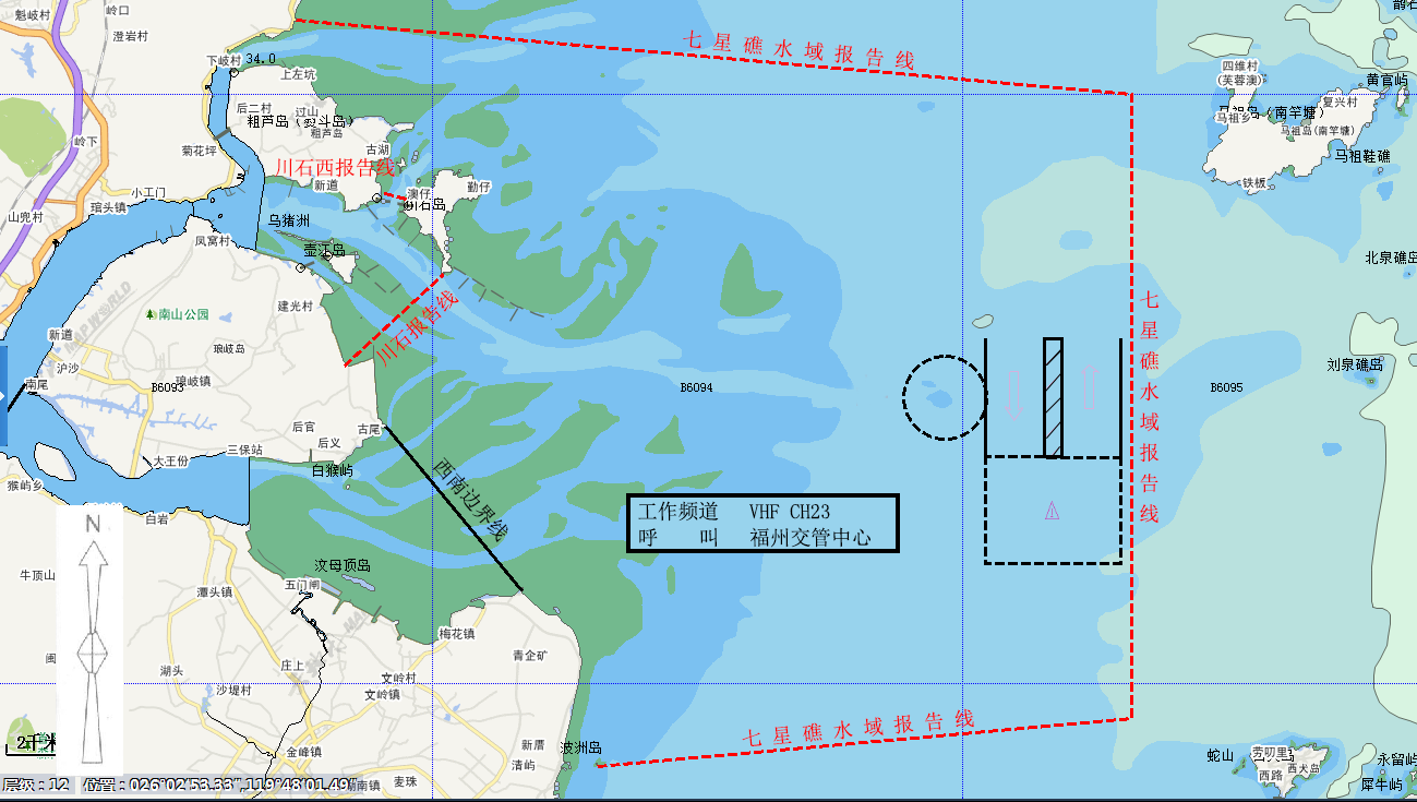
2.闽江口定线制VTS区域:是指由七星礁水域报告线、川石报告线、川石西报告线、西南边界线以及港内岸线围成的水域。
西南边界线:由26°01′35″N/119°41′41″E与26°04′22″N/119°39′07″E两点组成的连线。
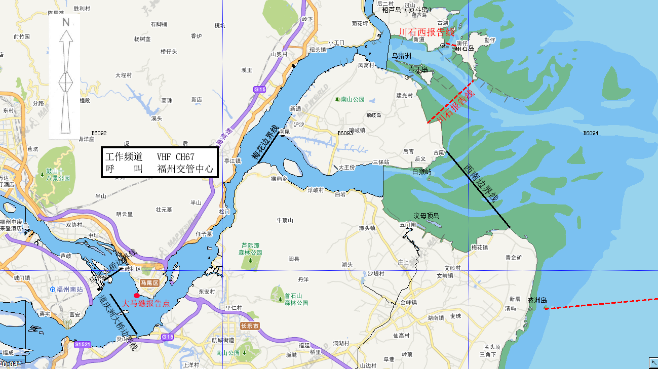
3.闽江口内港区VTS区域:是指由川石报告线、川石西报告线、三江口大桥边界线、道庆洲大桥边界线、梅花边界线以及港内岸线围成的水域。
梅花边界线:由26°05′05″N/119°32′19″E和26°03′55″N/119°31′27″E两点组成的连线。
4.松下港区VTS区域:是指由北报告线、北限岛报告线、竹排屿报告线、南边界线以及岸线围成的水域。
南边界线:由25°41′14″N/119°34′26″E、25°40′52″N/119°34′26″E和25°40′52″N/119°36′49″E三点组成的连线。
5.江阴港区VTS区域:是指由仁屿报告线、硋屿报告线、北边界线以及岸线围成的水域。
北边界线:由25°26′00″N/119°20′43″E和25°26′00″N/119°26′22″E两点组成的连线。
(二)船舶报告线(点)位置:
1.罗源湾港区VTS
可门口报告线:以可门角灯桩(26°25′42.6″N/119°50′10.0″E)为圆心,3海里为半径,方位338°~150°的圆弧线。
2.闽江口定线制VTS
(1)七星礁水域报告线:由26°11′15.0″N/119°37′25.2″E、26°10′00.0″N/119°53′12.0″E、25°59′24.0″N/119°53′12.0″E和25°58′36.0″N/119°43′06.6″E四点组成的连线。
(2)川石报告线:由川石南灯桩(26°06′57.6″N/119°40′11.5″E)和白云山引导灯桩前(26°05′22.6″N/119°38′18.7″E)两点组成的连线。
(3)川石西报告线:由26°08′20″N/119°39′01″E和26°08′13″N/119°39′30″E两点组成的连线。
3.闽江口内港区VTS
(1)川石报告线:由川石南灯桩(26°06′57.6″N/119°40′11.5″E)和白云山引导灯桩前(26°05′22.6″N/119°38′18.7″E)两点组成的连线。
(2)川石西报告线:由26°08′20″N/119°39′01″E和26°08′13″N/119°39′30″E两点组成的连线。
(3)大马礁报告点:航经正横大马礁灯桩(25°59′04.0″N/119°26′33.4″E)
4.松下港区VTS
(1)北报告线:以乌猪岛灯桩(25°41′49″N/119°40′00″E)为圆心,5海里为半径,330°~065°的圆弧线。
(2)北限岛报告线:由25°40′52″N/119°36′49″E和25°41′49″N/119°40′00″E两点组成的连线。
(3)竹排屿报告线:由25°41′49″N/119°40′00″E和25°43′54″N/119°45′02″E两点组成的连线。
5.江阴港区VTS
(1)仁屿报告线:由25°19′45″N/119°35′39″E和25°16′14″N/119°34′24″E两点组成的连线。
(2)硋屿报告线:由25°16′14″N/119°34′24″E、硋屿灯桩(25°20′47.1″N/119°22′03.9″E)、25°18′51″N/119°18′11″E三点组成的连线。
(三)VHF频道
福州VTS各分区及VHF工作频道如下:
分 区 工作频道
罗源湾港区VTS区域 VHF CH12
闽江口定线制VTS区域 VHF CH23(双工)
闽江口内港区VTS区域 VHF CH67
松下港区VTS区域 VHF CH72
江阴港区VTS区域 VHF CH12
在该分区船舶应呼叫福州交管中心,并必须在相应VHF频道上保持守听。
(四)VTS区域示意图
| 中国 | 福州交管中心 | 罗源湾港区
VTS区域 |
版本号
第三版 |
修正日期
2020年1月 |

本图不可用于航海
| 中国 | 福州交管中心 | 闽江口定线制
VTS区域 |
版本号
第三版 |
修正日期
2020年1月 |
本图不可用于航海
| 中国 | 福州交管中心 | 闽江口内港区
VTS区域 |
版本号
第三版 |
修正日期
2020年1月 |
本图不可用于航海
| 中国 | 福州交管中心 | 松下港区VTS区域 | 版本号
第三版 |
修正日期
2020年1月 |

本图不可用于航海
| 中国 | 福州交管中心 | 江阴港区VTS区域 | 版本号
第三版 |
修正日期
2020年1月 |

本图不可用于航海
二、船舶报告
(一)适用船舶
1.国际航行船舶;
2.乘客定额超过50客位的客船(渡船除外);
3.载运危险货物的船舶;
4.从事拖带及其他有碍通航安全的作业船舶;
5.操纵能力受到限制的船舶;
6.300总吨及以上中国籍船舶;
7.其他船舶可自愿参加船舶动态报告。
(二)预报(仅适用于进出VTS覆盖区停泊及作业的船舶)
1.报告时机:进出VTS覆盖区前24小时。
2.报告:福州交管中心。
3.报告方式:福州港船舶进出港监管服务平台、邮件或传真。
4.报告内容:船舶(船名、呼号)、船舶种类、时间、吃水、货物、船舶尺寸、船舶动态计划及其他需要报告的信息。
(三)进港报告
1.报告时机:通过报告线(点)和/或抵近泊位或者锚地。
2.报告:福州交管中心。
3.报告方式:
罗源湾港区VTS区域 VHF CH12
闽江口定线制VTS区域 VHF CH23(双工)
闽江口内港区VTS区域 VHF CH67
松下港区VTS区域 VHF CH72
江阴港区VTS区域 VHF CH12
4.报告内容:船舶(船名、呼号)、动态、载货(客)情况、吃水及交管中心要求的其他信息。
(四)抵港报告
1.报告时机:船舶抵达VTS覆盖区内泊位或者锚地。
2.报告:福州交管中心。
3.报告方式:
罗源湾港区VTS区域 VHF CH12
闽江口定线制VTS区域 VHF CH23(双工)
闽江口内港区VTS区域 VHF CH67
松下港区VTS区域 VHF CH72
江阴港区VTS区域 VHF CH12
4.报告内容:船舶(船名、呼号)、时间、船位等。
(五)开航报告
1.报告时机:船舶离泊或起锚前。
2.报告:福州交管中心。
3.报告方式:
罗源湾港区VTS区域 VHF CH12
闽江口定线制VTS区域 VHF CH23(双工)
闽江口内港区VTS区域 VHF CH67
松下港区VTS区域 VHF CH72
江阴港区VTS区域 VHF CH12
4.报告内容:船舶(船名、呼号)、时间、船位及下一港等。
(六)离港报告
1.报告时机:船舶通过报告线离开VTS区域。
2.报告:福州交管中心。
3.报告方式:
罗源湾港区VTS区域 VHF CH12
闽江口定线制VTS区域 VHF CH23(双工)
闽江口内港区VTS区域 VHF CH67
松下港区VTS区域 VHF CH72
江阴港区VTS区域 VHF CH12
4.报告内容:船舶(船名、呼号)、时间(通过报告线时间)、船位等。
(七)变化报告(仅适用于进出VTS区域停泊及作业的船舶)
1.报告时机:船舶预报计划信息发生变化。
2.报告:福州交管中心。
3.报告方式:福州港船舶进出港监管服务平台、邮件或传真。
4.报告内容:变化的项目。
(八)紧急和异常情况报告
1.报告时机:
(1)交通事故、污染事故、人员意外、保安事件以及其他影响航行安全的紧急情况;
(2)助航标志或者导航设施移位、灭失、损坏、异常;
(3)有碍航行安全的障碍物、漂浮物以及其他妨碍航行安全的异常情况。
2.报告:福州交管中心。
3.报告方式:
罗源湾港区VTS区域 VHF CH12
闽江口定线制VTS区域 VHF CH23(双工)
闽江口内港区VTS区域 VHF CH67
松下港区VTS区域 VHF CH72
江阴港区VTS区域 VHF CH12
4.报告内容:船名、国籍、时间、地点、事件经过(或紧急异常情况)、请求以及交管中心要求的其他情况。
(九)活动报告
1.报告时机(应在以下行动之前报告):
(1)拆修主机、锅炉、锚机、舵机以及其他影响船舶操纵性能的设备;
(2)试车、试航;
(3)校正罗经;
(4)释放救生艇筏;
(5)其他影响通航安全的作业。
2.报告:福州交管中心
3.报告方式:
罗源湾港区VTS区域 VHF CH12
闽江口定线制VTS区域 VHF CH23(双工)
闽江口内港区VTS区域 VHF CH67
松下港区VTS区域 VHF CH72
江阴港区VTS区域 VHF CH12
4.报告内容:船舶(船名、呼号)、船位、作业内容及交管中心要求报告的其他信息。
三、引航
(一)引航报告
1.报告时机:引航员登离轮。
2.报告:福州交管中心。
3.报告方式:
罗源湾港区VTS区域 VHF CH12
闽江口定线制VTS区域 VHF CH23(双工)
闽江口内港区VTS区域 VHF CH67
松下港区VTS区域 VHF CH72
江阴港区VTS区域 VHF CH12
4.报告内容:船舶(船名、呼号)、登离轮时间和水域、引航员编号等。
(二)强制引航船舶
1.外籍船舶;
2.法律法规规定应当申请引航的中国籍船舶。
(三)引航员登离轮水域
| 序号 | 港区 | 区域 | 船舶要求 | 天气要求 | 特殊要求 | 备注 |
| 1. | 福州罗源湾港区1号 | 26°26′.58N,119°53′.10E
26°26′.81N,119°53′.01E 26°26′.62N,119°51′.75E 26°26′.40N,119°51′.80E |
风力<6级或浪高<2.0米时使用 | |||
| 2. | 福州罗源湾港区2号 | 26°25′.95N,119°49′.33E
26°26′.17N,119°49′.28E 26°25′.82N,119°48′.70E 26°25′.60N,119°48′.72E
|
风力≥6级或浪高≥2.0米时使用
|
载重吨>7万吨级船舶仅供离轮时使用。其它船舶可登离轮使用 | ||
| 3. | 福州闽江口内港区1号 | 26°07′.18N,119°39′.33E
26°07′.45N,119°39′.48E 26°07′.88N,119°37′.57E 26°08′.15N,119°37′.75E |
风力<6级或浪高<2.0米时使用 | |||
| 4. | 福州闽江口内港区2号 | 26°04′.85N/119°48′.40E
26°04′.93N/119°48′.40E 26°04′.91N/119°47′.80E 26°04′.99N/119°47′.80E |
风力<6级或浪高<2.0米时使用 | 船宽≧35米,或拖带船舶申请引航时使用 | ||
| 5. | 福州闽江口内港区3号 | 26°05′.38N,119°43′.73E
26°05′.44N,119°43′.73E 26°05′.50N,119°43′.05E 26°05′.44N,119°43′.05E |
风力≥6级或浪高≥2.0米时使用 |
船宽≧35米,或拖带船舶申请引航时使用 | ||
| 6. | 闽江口4号 | 以点26°17′.70N/119°50′.50E为圆心,半径0.3海里 | 风力<6级或浪高<2.0米时使用 | |||
| 7. | 福州江阴港区1号 | 以点25°13′.80N,119°43′.00E为圆心,半径0.5海里 | ≥20万吨级船舶使用 | 风力<6级或浪高<2.0米时使用 | ||
| 8. | 福州江阴港区2号 | 25°16′.80N/119°38′.66E
25°16′.60N/119°38′.58E 25°16′.97N/119°37′.55E 25°17′.17N/119°37′.63E |
<20万吨级船舶使用 | 风力<6级或浪高<2.0米时使用 | ||
| 9. | 福州江阴港区3号 | 25°17′.69N/119°35′.50E
25°17′.87N/119°35′.56E 25°18′.20N/119°34′.52E 25°18′.00N/119°34′.45E |
风力≥6级或浪高≥2.0米时使用 |
|
||
| 10. | 福州松下港区新1号 | 25°44′.43N,119°44′.78E
25°43′.81N,119°43′.90E 25°43′.98N,119°43′.75E 25°44′.61N,119°44′.63E |
≥10万吨级船舶使用 | 风力<6级或浪高<2.0米时使用 | 使用福清湾二期航道。 | |
| 11. | 福州松下港区新2号 | 25°43′.08N,119°42′.02E
25°43′.22N,119°42′.01E 25°43′.07N,119°40′.93E 25°42′.93N,119°40′.96E |
﹤10万吨级船舶使用 | 风力<6级或浪高<2.0米时使用 | 使用福清湾二期航道。 | |
| 12. | 福州松下港区新3号 | 以点25°44′.26N,119°38′.53E为圆心,半径0.1海里 | 风力≥6级或浪高≥2.0米时使用。 | 仅供离轮时使用。使用福清湾二期航道。 |
四、船舶交通服务
(一)服务内容
1.信息服务;
2.助航服务(须请求);
3.交通组织服务;
4.支持联合行动。
(二)工作语言
汉语普通话或英语
(三)工作时间
北京时间0000-2400。
五、其他信息
(一)当地海事机构和港口的特别规定
1.《福州市海上交通安全管理条例》
2.《闽江口水域船舶定线制》和《闽江口水域船舶报告制》
(二)有助于船舶进出港或通过的相关信息
1.高速客船在港内航行,最高静水速度不得超过十五节。
2.长门大桥净空高度55.1米,琅岐闽江大桥净空高度55米,青洲大桥净空高度43米。
六、获取信息途径
(一)相关信息发布网站网址
1.中华人民共和国海事局: http://www.msa.gov.cn
2.福建海事局:http://www.fj.msa.gov.cn
3.气象相关信息网站:福建气象http://fj.cma.gov.cn
4.中国海事局对外发布航海图书在线服务网站:http://www.chart.msa.gov.cn
(二)当地海事机构、港口当局、引航单位等联系方式
1.福州海事局交管中心
邮政编号:350015
通信地址:福州市马尾区港口路35号
联系电话:+86-591-83684018
图文传真:+86-591-83985000
2.福建省福州港口发展中心
邮政编号:350007
通信地址:福州市仓山区六一南路255号
联系电话:+86-591-83684359
3.福州港引航站
邮政编号:350015
通信地址:福州市马尾区港口路3号
联系电话:+86-591-83984991
图文传真:+86-591-83984990
Fuzhou Vessel Traffic Services Guide
- VHF Procedures
1.1 VTS Area
Fuzhou VTS area consists of Luoyuanwan Harbor,Minjiangkou TSS,Minjiangkou Inner Harbor,Songxia Harbor and Jiangyin Harbor.
(1) Luoyuanwan harbor VTS area: The water area is bounded by Kemenkou report line and the inner harbor’s coastlines.
(2)Minjiangkou TSS VTS area:The water area is bounded by Qixingjiao report line,Chuanshi report line,Chuanshi West report line,Southwest boundary line and the inner harbor’s coastlines.
Southwest boundary line:The line joining 26°01′35″N/119°41′41″E and 26°04′22″N/119°39′07″E.
(3)Minjiangkou inner VTS area:The water is bounded by Chuanshi report line,Chuanshi West report line,Sanjiangkou Bridge boundary line,Daoqingzhou Bridge boundary line,Meihua boundary line and the inner harbor’s coastlines.
Meihua boundary line: The line joining 26°05′05″N/119°32′19″E and 26°03′55″N/119°31′27″E.
(4)Songxia harbor VTS area:The water area is bounded by North report line,Beixiandao report line,Zhupaiyu report line, South boundary line and the inner harbor’s coastlines.
South boundary line: The line joining 25°41′14″N/119°34′26″E,25°40′52″N/119°34′26″E and 25°40′52″N/119°36′49″E.
(5)Jiangyin harbor VTS area:The water area is bounded by Renyu report line, Aiyu report line, North boundary and the inner harbor’s coastlines.
North boundary line: The line joining 25°26′00″N/119°20′43″E and 25°26′00″N/119°26′22″E
1.2 Report Lines and Points
1.2.1 Luoyuanwan harbor VTS area
Kemenkou report line: The part of the circle with radius of 3 miles and bearing 338°~150°from Kemenjiao light beacon (26°25′42.6″N/119°50′10.0″E).
1.2.2 Minjiangkou TSS VTS area
(1) Qixingjiao report line: The line joining 26°11′15.0″N/119°37′25.2″E, 26°10′00.0″N/119°53′12.0″E, 25°59′24.0″N/119°53′12.0″E and 25°58′36.0″N/119°43′06.6″E.
(2) Chuanshi report line: The line joining Chuanshi South Light beacon (26°06′57.6″N/119°40′11.5″E )and Front leading light beacon of Baiyunshan (26°05′22.6″N/119°38′18.7″E).
(3) Chuanshi west report line: The line joining 26°08′20″N/119°39′01″E and 26°08′13″N/119°39′30″E.
1.2.3 Minjiangkou Inner VTS Area
(1) Chuanshi report line: The line joining Chuanshi south light beacon (26°06′57.6″N/119°40′11.5″E )and Front leading light beacon of Baiyunshan (26°05′22.6″N/119°38′18.7″E).
(2) Chuanshi West report line: The line joining 26°08′20″N/119°39′01″E and 26°08′13″N/119°39′30″E.
(3) Damajiao report point: Abeam The Damajiao light beacon(25°59′04.0″N/119°26′33.4″E)
1.2.4 Songxia harbor VTS area
(1) North report line: The part of the circle with radius of 5 miles and bearing 330°~065°from Wuzu island light beacon (25°41′49″N/119°40′00″E).
(2) Beixiandao report line: The line joining 25°40′52″N/119°36′49″and 25°41′49″N/119°40′00″E.
(3) Zhupaiyu report line: The line joining 25°41′49″N/119°40′00″E、25°43′54″N/119°45′02″E.
1.2.5 Jiangyin harbor VTS area
(1)Renyu report line: The line joining 25°19′45″N/119°35′39″E and 25°16′14″N/119°34′24″E.
(2) Aiyu report line: 25°16′14″N/119°34′24″E, Aiyu light beacon(25°20′47.1″N/119°22′03.9″E), 25°18′51″N/119°18′11″E.
1.3 VHF Channel
Fuzhou VTS sectors and VHF working channels as follows:
Sector Working channel
Luoyuanwan harbor VTS area VHF CH12
Minjiangkou TSS VTS area VHF CH23
Minjiangkou inner harbor VTS area VHF CH67
Songxia harbor VTS area VHF CH72
Jiangyin harbor VTS area VHF CH12
Vessels should call Fuzhou VTS and maintain a continuous listening watch on the appropriate VHF channel.
1.4 VTS Plans
| CHINA | FUZHOU
VTS CENTER |
LUOYUANWAN HARBOR
VTS AREA |
EDITION
No.03 |
REVISION DATE
JANUARY 2020 |

Not to be used for navigation
| CHINA | FUZHOU
VTS CENTER |
MINJIANGKOU TSS
VTS AREA |
EDITION
No.03 |
REVISION DATE
JANUARY 2020 |
Not to be used for navigation
| CHINA | FUZHOU
VTS CENTER |
MINJIANGKOU INNER HARBOR VTS AREA | EDITION
No.03 |
REVISION DATE
JANUARY 2020 |

Not to be used for navigation
| CHINA | FUZHOU
VTS CENTER |
SONGXIA HARBOR
VTS AREA |
EDITION
No.03 |
REVISION DATE
JANUARY 2020 |

Not to used for navigation
| CHINA | FUZHOU
VTS CENTER |
JIANGYIN HARBOR
VTS AREA |
EDITION
No.03 |
REVISION DATE
JANUARY 2020 |

Not to be used for navigation
- Reports
2.1 Applicability:
(1) Vessels engaged in international voyages;
(2) Passenger Ships with capacity of 50 passengers or above (except ferries);
(3) Vessels carrying dangerous cargo;
(4) Vessels engaged in towing operation;
(5) Vessels restricted in their ability to maneuver;
(6) Chinese vessels of 300 GT or above;
(7) Other vessels shall not be obliged to make position report but may do so.
2.2 Pre-report (only for the vessels intend mooring in VTS area )
WHEN: 24 hours before enter/out VTS area
To: Fuzhou VTS
VIA: The Supervision Service System for Ships Entering and Leaving Fuzhou port ; Email ; Fax.
GIVING: 1.Ship′s name/ Call sign; 2.Ship′s type; 3.Time; 4.Ship′s draft;5.Cargo;6. Ship′s dimension;7.Movement or Plan ,etc.
2.3 Entry Report
WHEN: Passing the VTS report line (point) and/or approaching the berth or anchorage.
TO: Fuzhou VTS
VIA:
Luoyuanwan harbor VTS area VHF CH12
Minjiangkou TSS VTS area VHF CH23
Minjiangkou inner harbor VTS area VHF CH67
Songxia harbor VTS area VHF CH72
Jiangyin harbor VTS area VHF CH12
GIVING: 1.Ship′s name/call sign; 2.Movement;3.Cargo/ Passenger on board; 4.Ship′s draft;5.Other information required by the VTS center.
2.4 Arrival Report
WHEN: Anchoring or securing to a berth within VTS waters.
TO: Fuzhou VTS
VIA:
Luoyuanwan harbor VTS area VHF CH12
Minjiangkou TSS VTS area VHF CH23
Minjiangkou inner harbor VTS area VHF CH67
Songxia harbor VTS area VHF CH72
Jiangyin harbor VTS area VHF CH12
GIVING: 1.Ship′s name/call sign; 2.Time;3. Ship′s position,etc.
2.5 Pre-move and Pre-departure Report
WHEN: Before moving or departing.
TO: Fuzhou VTS
VIA:
Luoyuanwan harbor VTS area VHF CH12
Minjiangkou TSS VTS area VHF CH23
Minjiangkou inner harbor VTS area VHF CH67
Songxia harbor VTS area VHF CH72
Jiangyin harbor VTS area VHF CH12
GIVING:1.Ship′s name/call sign; 2.Time; 3.Ship′s position; 4.Next port of call,ect.
2.6 Outbound Report
WHEN: Passing VTS report line (point) and/or departing from the VTS area.
TO: Fuzhou VTS
VIA:
Luoyuanwan harbor VTS area VHF CH12
Minjiangkou TSS VTS area VHF CH23
Minjiangkou inner harbor VTS area VHF CH67
Songxia harbor VTS area VHF CH72
Jiangyin harbor VTS area VHF CH12
GIVING: 1.Ship′s name/call sign;2. Time passing report line;3. Ship′s position,ect.
2.7 Deviation Reports( only for the Vessels intend mooring in VTS area )
WHEN: Any change in details given in the pre-entry report.
TO: Fuzhou VTS
VIA: The Supervision Service System for Ships Entering and Leaving Fuzhou Port ; Email ; Fax.
GIVING: Any changed information.
2.8 Emergency and Abnormality Report
WHEN:
(1)Being involved in traffic accident and pollution
incident,person contretemps,security event or any other emergent situations which may affect navigational safety;
(2)Finding aids to navigation or navigational facilities
off-position, missing, damaged or abnormal;
(3)Finding obstacles, floating objects or any other
abnormal situation which may affect navigational safety.
TO: Fuzhou VTS
VIA:
Luoyuanwan harbor VTS area VHF CH12
Minjiangkou TSS VTS area VHF CH23
Minjiangkou inner harbor VTS area VHF CH67
Songxia harbor VTS area VHF CH72
Jiangyin harbor VTS area VHF CH12
GIVING:
1.Ship′s name; 2.Nationality; 3.Time; 4. Position;
5.Process of the accident (Full details of emergency or abnormal situation); 6.Request; 7.Other information required by the VTS center.
2.9 Activities Reports
WHEN: Carrying out any of the following operations:
(1)Overhauling main engine,boiler,windlass,steering gear or other important equipment impeding ship maneuverability;
(2) ship trials ,Testing main engine;
(3) calibrating magnetic compass;
(4)Launching of vessels ‘lifeboat or life-raft;
(5) Other activities impeding the safety of navigation.
TO: Fuzhou VTS
VIA:
Luoyuanwan harbor VTS area VHF CH12
Minjiangkou TSS VTS area VHF CH23
Minjiangkou inner harbor VTS area VHF CH67
Songxia harbor VTS area VHF CH72
Jiangyin harbor VTS area VHF CH12
GIVING:1.Ship′s name/call sign; 2.Ship′sposition;
3.Operaional content; 4.Other information required by the VTS center.
3 Pilotage
3.1 Pilot Report
WHEN: Pilot embarking or disembarking.
TO: Fuzhou VTS
VIA:
Luoyuanwan harbor VTS area VHF CH12
Minjiangkou TSS VTS area VHF CH23
Minjiangkou inner harbor VTS area VHF CH67
Songxia harbor VTS area VHF CH72
Jiangyin harbor VTS area VHF CH12
GIVING: 1.Ship′s name/call sign;2. Pilot boarding time and position;3. Pilot number,ect.
3.2 Pilotage is compulsory for:
(1) Vessels of foreign nationality;
(2) Chinese vessels those are required for pilotage
by the relevant laws and regulations.
3.3 Pilot boarding stations (PBS)
| NO. | Port Area | Pilot Boarding Ground | Vessel | Weather | Special
Requirement |
remark |
| 1 | Luoyuanwan Port Area of Fuzhou PBS NO.1 | 26°26′.58N,119°53′.10E
26°26′.81N,119°53′.01E 26°26′.62N,119°51′.75E 26°26′.40N,119°51′.80E |
Wind-force<6
OR Wave-height <2.0m |
|||
| 2 | Luoyuanwan Port Area of Fuzhou PBS NO.2 | 26°25′.95N,119°49′.33E
26°26′.17N,119°49′.28E 26°25′.82N,119°48′.70E 26°25′.60N,119°48′.72E |
Wind-force≥6
OR Wave-height≥2.0m
|
For vessels> 70,000 ton-class only for embarking,the others can use in embarking or disembarking | ||
| 3 | Minjiangkou Inner Port Area of Fuzhou PBS NO.1 | 26°07′.18N,119°39′.33E
26°07′.45N,119°39′.48E 26°07′.88N,119°37′.57E 26°08′.15N,119°37′.75E |
Wind-force<6
OR Wave <2.0m |
|||
| 4 | Minjiangkou Inner Port Area of Fuzhou PBS NO.2 | 26°04′.85N/119°48′.40E
26°04′.93N/119°48′.40E 26°04′.91N/119°47′.80E 26°04′.99N/119°47′.80E |
Wind-force<6
OR Wave <2.0m |
1.Breadth≥35m
2.Towing ship |
||
|
5 |
Minjiangkou Inner Port Area of Fuzhou PBS NO.3 | 26°05′.38N,119°43′.73E
26°05′.44N,119°43′.73E 26°05′.50N,119°43′.05E 26°05′.44N,119°43′.05E |
Wind-force≥6
OR Wave≥2.0m |
1.Breadth≥35m
2.Towing ship |
||
| 6 | Minjiangkou Inner Port Area of Fuzhou PBS NO.4 | The circle with radius of 0.3 nautical miles from the point 26°17′.70N/119°50′.50E | Wind-force<6
OR Wave <2.0m |
|||
| 7 | Jiangyin Port Area of Fuzhou PBS NO.1 | The circle with radius of 0.5 nautical miles from the point 25°13′.80N/119°43′.00E | For vessels≥200,000 ton-class | Wind-force<6
OR Wave <2.0m |
||
| 8 | Jiangyin Port Area of Fuzhou PBS NO.2 | 25°16′.80N/119°38′.66E
25°16′.60N/119°38′.58E 25°16′.97N/119°37′.55E 25°17′.17N/119°37′.63E |
For vessels<200,000 ton-class | Wind-force<6
OR Wave <2.0m |
||
| 9 | Jiangyin Port Area of Fuzhou PBS NO.3 | 25°17′.69N/119°35′.50E
25°17′.87N/119°35′.56E 25°18′.20N/119°34′.52E 25°18′.00N/119°34′.45E |
Wind-force≥6
OR Wave≥2.0m |
|||
| 10 | Songxia Port Area of Fuzhou PBS New NO.1 | 25°44′.43N,119°44′.78E
25°43′.81N,119°43′.90E 25°43′.98N,119°43′.75E 25°44′.61N,119°44′.63E |
For vessel≥ 100000 ton-class | Wind-force<6
OR Wave <2.0m |
Use the fuqingwan no.2 fair way | |
| 11 | Songxia Port Area of Fuzhou PBS New NO.2 | 25°43′.08N,119°42′.02E
25°43′.22N,119°42′.01E 25°43′.07N,119°40′.93E 25°42′.93N,119°40′.96E |
For vessel < 100000 ton-class | Wind-force<6
OR Wave <2.0m |
Use the fuqingwan no.2 fair way | |
| 12 | Songxia Port Area of Fuzhou PBS New NO.3 | The circle with radius of 0.1 nautical miles from the point 25°44′.26N/119°38′.53E | Wind-force≥6
OR Wave≥2.0m |
Use the fuqingwan no.2 fairway and only for Drop pilot |
- Vessel Traffic Services
4.1 Type of services provided
4.1.1 Information service;
4.1.2 Navigational assistance service (on request);
4.1.3 Traffic organization service;
4.1.4 Allied services.
4.2 Working Language
Mandarin and/or English.
4.3 Working Time
0000-2400(Beijing time).
- Additional Information
5.1 Special rules and regulations for local Maritime Safety Administrations and port authorities
5.1.1 The Regulations of Fuzhou Municipality on Maritime Traffic Safety.
5.1.2 Ship Routing System in Minjiangkou Water Area and Ship Reporting System in Minjiangkou Water Area .
5.2 Relevant information to facilitate the vessel’s entry and exit or passage.
5.2.1 The maximum hydrostatic velocity of high-speed passenger ship in the port water is 15 knots.
5.2.2 Bridge height clearance information
The Changmen Bridge: 55.1 meters.
The Langqi minjiang Bridge: 55 meters.
The Qingzhou Bridge: 43 meters.
- Information Inquiry
6.1 Address of websites publishing related information:
(1)CHINA MSA :http://www.msa.gov.cn
(2)FUJIAN MSA: http://www.fj.msa.gov.cn
(3)FUJIAN Weather bureau: http://fj.cma.gov.cn
(4)China Maritime Navigation Book Online Service Website:http://www.chart.msa.gov.cn
6.2 Contact information of local maritime and port authorities,pilot station, etc.
(1) Fuzhou VTS center
Post Code:350015
Office Add:35 Gangkou Road,Mawei District, Fuzhou, China
Tel: +86-591-83684018
Fax: +86-591-83985000
(2) Fuzhou Port Authority:
Post Code:350007
Office Add:255 liuyinan Road,Cangshan District, Fuzhou, China
Tel: +86-591-83684359
(3) Fuzhou pilot station:
Post Code:350015
Office Add:6 Gangkou Road,Mawei District, Fuzhou, China
Tel: +86-591-83984991
Fax: +86-591-83984990
莆田VTS服务指南
一、VHF程序
(一)区域范围
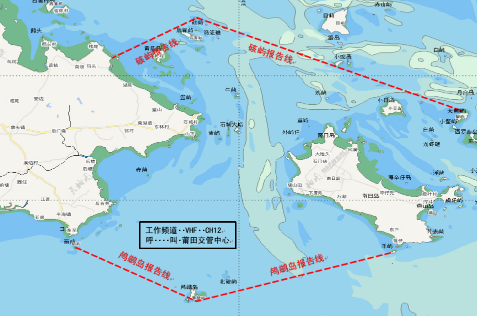
由鸬鹚岛报告线、硋屿报告线两条报告线与岛屿岸线所围成的通航水域。
鸬鹚岛报告线:
由箭屿(25°09′43″N/119°16′30″E)到鸬鹚岛(25°07′06″N/119°22′03″E)到羊屿(25°09′29″N/119°31′05″E)三点组成的连线;
硋屿报告线:
由25°16′14″N/119°34′24″E、硋屿灯桩(25°20′47.1″N/119°22′03.9″E)、25°18′51″N/119°18′11″E三点组成的连线。
(三)VHF工作频道
莆田VTS工作频道为VHF CH 12,船舶应呼叫莆田交管中心,并必须在VHF12频道上保持守听。
(四)VTS区域示意图
| 中国 | 莆田交管中心 | 莆田VTS区域 | 版本号
第一版 |
修正日期
2021年7月 |
本图不可用于航海
二、船舶报告
(一)适用船舶
1.国际航行船舶;
2.乘客定额超过50客位的客船(渡船除外);
3.载运危险货物的船舶;
4.从事拖带的船舶;
5.操纵能力受到限制的船舶;
6.300总吨及以上中国籍船舶。
7.其他船舶可自愿参加船舶动态报告。
(二)进港报告
1.报告时机:通过报告线(点)和/或抵近泊位或者锚地。
2.报告:莆田交管中心。
3.报告方式:VHF CH12。
4.报告内容:船舶(船名、呼号)、动态、载货(客)情况、吃水及交管中心要求的其他信息。
(三)抵港报告
1.报告时机:船舶抵达VTS区域内泊位或者锚地。
2.报告:莆田交管中心。
3.报告方式: VHF CH12。
4.报告内容:船舶(船名、呼号)、时间、船位等。
(四)开航报告
1.报告时机:船舶离泊或起锚前。
2.报告:莆田交管中心。
3.报告方式:VHF CH12。
4.报告内容:船舶(船名、呼号)、时间、船位及下一港等。
(五)离港报告
1.报告时机:船舶通过报告线离开VTS区域。
2.报告:莆田交管中心。
3.报告方式:VHF CH12。
4.报告内容:船舶(船名、呼号)、时间(通过报告线时间)、船位等。
(六)变化报告
1.报告时机:船舶预报计划信息发生变化。
2.报告:莆田交管中心。
3.报告方式:传真、电话、VHF CH12。
4.报告内容:变化的项目。
(七)紧急和异常情况报告
1.报告时机:
(1)交通事故、污染事故、人员意外、保安事件以及其他影响航行安全的紧急情况;
(2)助航标志或者导航设施移位、灭失、损坏、异常;
(3)有碍航行安全的障碍物、漂浮物以及其他妨碍航行安全的异常情况。
2.报告:莆田交管中心。
3.报告方式:VHF CH12、VHF CH16、电话。
4.报告内容:船名、国籍、时间、地点、事件经过(或紧急、异常情况)、请求以及VTS中心要求的其他情况。
(八)活动报告
1.报告时机(应在以下行动之前报告):
(1)拆修主机、锅炉、锚机、舵机以及其他影响船舶操纵性能
的设备;
(2)试航、试车;
(3)校正罗经;
(4)释放救生艇筏;
(5)其他影响通航安全的作业。
2.报告:莆田交管中心。
3.报告方式:VHF CH12、VHF CH16、电话。
4、报告内容:船舶(船名、呼号)、船位、作业内容及交管中心要求报告的其他信息。
三、引航
(一)引航报告
1.报告时机:引航员登离轮。
2.报告:莆田交管中心。
3.报告方式:VHF CH12。
4.报告内容:船舶(船名、呼号)、登离船时间和地点、引航员编号等。
(二)强制引航船舶
1.外籍船舶(目前莆田交管覆盖区为非开放水域,一般情况下外籍船舶不得进入,此处专指特殊情况下进入覆盖区水域的外籍船舶);
2.法律法规规定应当申请引航的中国籍船舶。
(三)引航员登离点 :
暂无。如有引航需求,请与莆田交管中心确认引航员登离点位置。
四、船舶交通服务
(一)信息服务;
(二)助航服务(须请求);
(三)交通组织服务;
(四)支持联合行动。
五、其他信息
南日水道为沿海中小型船舶习惯的自然航道,通航环境复杂:石南轮渡渡运航线与该自然航道交叉,周边水域海底管道多,渔业养殖区与风电施工区密集,渔船、工程作业船较多。各船舶应当根据当时的环境和情况使用安全航速航行,谨慎驾驶。
六、获取信息途径
(一)相关信息发布网站网址
1.中华人民共和国海事局: http://www.msa.gov.cn/
2.福建海事局:http://www.fj.msa.gov.cn/
3.福建气象:http://qxfw.fjqx.gov.cn
4.中国海事航海图书在线服务网站:
http://www.chart.msa.gov.cn(中国海事局对外发布电子海图、纸质航海图书资料的公共服务平台)
5.湄洲湾港口发展中心官网:
http://jtyst.fujian.gov.cn/mzwgk/
(二)当地海事机构、港口发展中心、引航单位、拖轮公司等联系方式
1.莆田交管中心
邮政编码:351100
通信地址:莆田市城厢区永乐路128号
联系电话:+86-594-2519516
图文传真:+86-594-2519512
电子邮箱:ptrcc@sina.com
2.湄洲湾港口发展中心兴化湾港务站
邮政编码:351100
通信地址:莆田市荔城区坊巷199号
联系电话:+86-594-2339951
3.当地引航单位联系方式
湄洲湾港引航站
联系电话:+86-594-2339965
4.拖轮公司联系方式
福建荔兴拖轮有限公司
联系电话:+86-594-5686979
Putian Vessel Traffic Services Guide
1.VHF Procedures
1.1 VTS Area
Putian VTS area bounded by Lucidao report line, Aiyu report line and the inner harbor’s coastlines.
1.2 Report lines and points
Lucidao report line:
The line joining Jianyu(25°09′43″N/119°16′30″E)and Lucidao(25°07′06″N/119°22′03″E)and Yangyu (25°09′29″N/119°31′05″E) .
Aiyu report line:25°16′14″N/119°34′24″E, Aiyu
light beacon(25°20′47.1″N/119°22′03.9″E), 25°18′51″
N/119°18′11″E.
1.3 VHF channel
Putian VTS Working channel is on VHF CH12.Vessels should call Putian VTS and maintain a continuous listening watch on the appropriate VHF Channel.
1.4 VTS Plans
| CHINA | PUTIAN
VTS CENTER |
PUTIAN
VTS AREA |
EDITION
No.01 |
REVISION DATE
JULY 2021 |

Not to be used for navigation
- Reports
2.1 Applicability:
(1) Vessels engaged in international voyages;(2) Passenger Ships with capacity of 50 passengers or above (except ferries);
(3) Vessels carrying dangerous cargo;
(4) Vessels engaged in towing operation;
(5) Vessels restricted in their ability to maneuver;
(6) Chinese vessels of 300 GT or above.(7) Other vessels shall not be obliged to make position report but may do so.
2.2 Entry Report
WHEN:Passing the VTS reporting line (point) and/or approaching the berth or anchorage.
TO:Putian VTS
VIA:VHF CH 12
GIVING:1.Ship′s name/callsign;2.Movement;3.Cargo/Passenger on board;4.Ship′s draft;5.Other imformation requiede by the VTS center.
2.3 Arrival Report
WHEN: Anchoring or securing to a berth within VTS area.
TO:Putian VTS
VIA:VHF CH 12
GIVING: 1.Ship′s name/callsign; 2.Time;3. Ship′s position,etc.
2.4 Pre-move and Pre-departure Report
WHEN: Before moving or departing.
TO: Putian VTS
VIA: VHF CH 12
GIVING: 1.Ship′s name/callsign;2.Time;3.Ship′s position;4.Next port of call,ect.
2.5 Outbound Report
WHEN: Passing VTS reporting line (point) and/or departing from the VTS area.
TO:Putian VTS
VIA:VHF CH 12
GIVING: 1.Ship′s name/callsign;2. Time passing report line;3. Ship′s position,ect.
2.6 Deviation Reports
WHEN: Any change in details given in the pre-entry report.
TO:Putian VTS
VIA: Fax,Telephone ,VHF CH 12
GIVING: Any changed information.
2.7 Emergency and Abnormality Report
WHEN:
(1)Being involved in traffic accident and pollution
incident,person contemps,security event or any other emergency situations which may affect navigational safety;
(2)Finding aids to navigation or navigational facilities
off-position, missing, damaged or abnormal;
(3)Finding obstacles, floating objects or any other
abnormal situation which may affect navigational safety.
TO:Putian VTS
VIA:VHF CH 12,VHF CH 16,Tel
GIVING:
1.Vessel′s name; 2.Nationality; 3.Time; 4. Position;
5.Process of the accident (Full details of emergency or abnormal situation); 6.Request; 7.Other information required by the VTS center.
2.8 Activities Reports
WHEN: Carrying out any of the following operations:
(1)Overhauling main engine,boiler,windlass,steering gear or other important equipment impeding ship maneuverability.
(2) Ship trials,Testing main engine;
(3) Calibrating magnetic compass;
(4)Launching of vessel’s lifeboat or life-raft.
(5)Other activities impeding the safety of navigation.
TO:Putian VTS
VIA:VHF CH 12
GIVING:1.Ship′s name/call sign;2.Ship′s position;
3.Operaional content; 4.Other information required by the VTS
center
- Pilotage
3.1 Pilot Report
WHEN: Pilot embarking or disembarking.
TO: Putian VTS
VIA: Fax or Telephone ;VHF CH 12
GIVING: 1.Ship′s name/callsign;2. Pilot boarding time and position;3. Pilot number,ect.
3.2 Pilotage is compulsory for:
(1) Vessels of foreign nationality.(Putian VTS coverage area is a non open water,vessels of foreign nationality are not allowed to enter.Here,it specifically refers to vessels of foreign nationality entering the coverage area under special circumstances.)
(2)Chinese Vessels that are required to apply for pilotage in accordance with the relevant laws and regulations.
- Vessel Traffic Services
4.1 Information service;
4.2 Navigational assistance service (on request);
4.3 Traffic organization service;
4.4 Allied services.
- Additional Information
Nanri fairway is a natural waterway used by coastal small and medium-sized ships,and the navigation environment is complex:Shinan ferry line crossing with the natural waterway,many seabed pipes in surrounding waters,intensive fishery and wind power construction areas,more fishing boats and engineering vessels.All ships shall navigate at a safe speed according to the environment and conditions at that time and drive with caution.
6.Information Inquiry
6.1 address of websites publishing related information:
(1) CHINA MSA:http://www.msa.gov.cn/
(2) FUJIAN MSA: http://www.fj.msa.gov.cn/
(3) Fujian Weather bureau :http://qxfw.fjqx.gov.cn
(4)China Maritime Navigation Book Online Website:
http://www.chart.msa.gov.cn
(5)Putian Port Authority:
http://jtyst.fujian.gov.cn/mzwgk/
6.2 Contact details of local maritime authority,pilot station,etc.
(1)Putian VTS center
Postal Code: 351100
Address: 128 Yongle Road ,Chengxiang District, Putian City,Fujian Province.
Tel: +86-594-2519516
Fax: +86-594-2519512
(2) Meizhouwan Port Authority:
Postal Code: 351100
Address: 199 Fang Road ,Licheng District, Putian City,Fujian Province.
Tel:+86-594-2339951
(3)Meizhouwan pilot station:
Tel:+86-594-2339965
(4) Fujian Lixin Tugs Co., Ltd:
Tel:+86-594-5686979
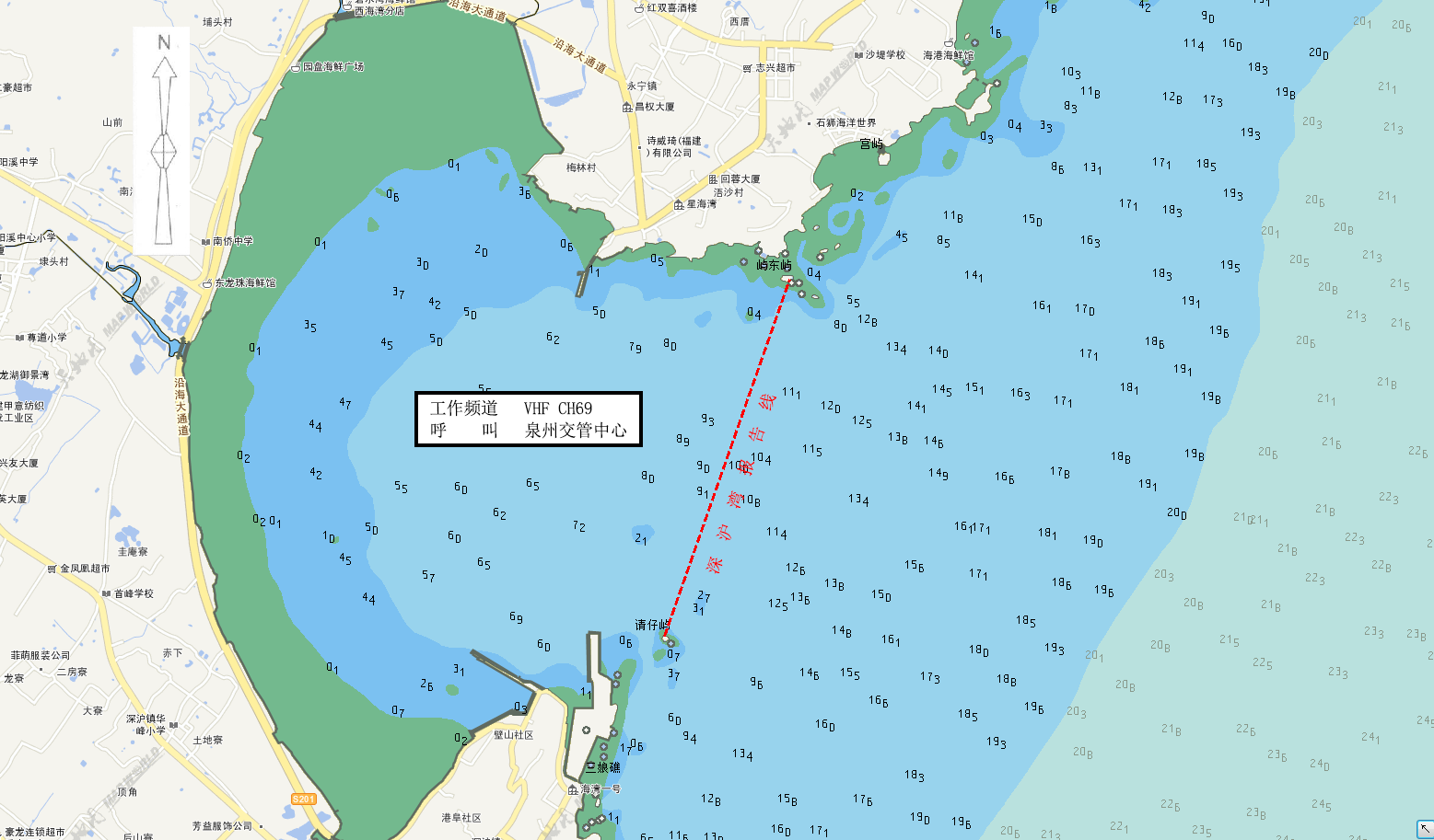
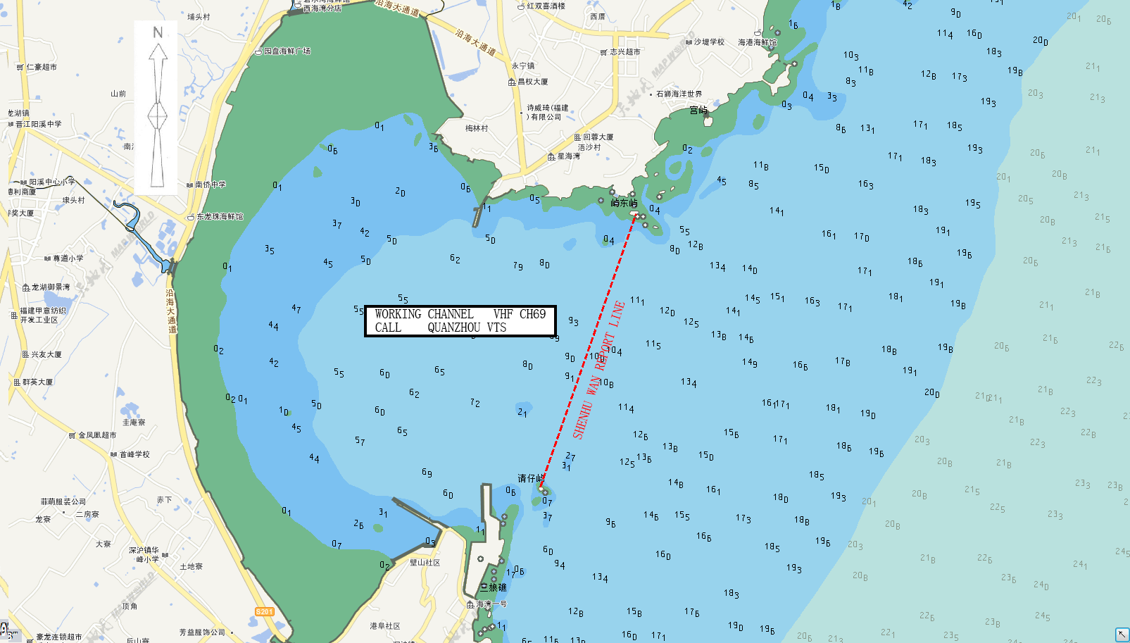
泉州VTS服务指南
一、VHF程序
(一)区域范围
泉州VTS区域由湄洲湾、泉州湾、锦尚湾、深沪湾和围头湾VTS区域组成。
1.湄洲湾VTS区域:是指由南报告线、东报告线、北报告线以及湄洲湾内岸线所围成的水域。
2.泉州湾VTS区域:是指由泉州湾报告线、北线以及港内岸线所围成的水域。
北线:由24°51′15″N/118°41′48″E和24°51′15″N/118°39′26″E两点组成的连线
3.锦尚湾VTS区域:是指由锦尚湾报告线以及港内岸线所围成的水域。
4.深沪湾VTS区域:是指由深沪湾报告线以及港内岸线所围成的水域。
5.围头湾VTS区域:是指由东南报告线、西南报告线、北报告线与港内岸线所围成的水域。
(二)船舶报告线(点)位置:
1.湄洲湾VTS
(1)南报告线:由鹅尾山东端(25°01′39″N/119°07′18″E)和剑屿灯塔(24°57′57″N/119°01′56″E)两点组成的连线。
(2)东报告线:由湄洲岛西北端(25°04′53″N/119°06′17″E)和山柄南端(25°06′44″N/119°06′02″E)两点组成的连线。
(3)北报告线:由LNG泉港北灯桩(25°13′47″N/118°55′30″E)和LNG秀屿北灯桩(25°14′05″N/118°58′44″E)两点组成的连线。
2.泉州湾VTS
(1)泉州湾报告线:由祥芝角灯塔(24°46′21″N/118°46′40″E)、泉州湾口(24°49′45″N/118°50′00″E)和烟墩山南(24°51′44″N/118°50′00″E)三点组成的连线。
(2)南乌礁报告点:航经正横南乌礁灯桩(24°49′37″N/118°42′23″E)
(3)内港1号灯浮报告点:航经正横内港1号灯浮(24°51′15″N 118°41′28″E)。
3.锦尚湾VTS
锦尚湾报告线:以锦尚堤头灯桩(24°43′12″N/118°44′40″ E)为圆心,2 海里为半径,方位035°至222°的圆弧线。
4.深沪湾VTS
深沪湾报告线:由永宁咀灯塔(24°39′58″N/118°41′57″E)和牛尾屿灯桩(24°38′09″N/118°41′15″E)两点组成的连线。
5.围头湾VTS
(1)东南报告线:由围头角灯塔(24°30′46″N/118°34′19″E)和围头湾6#灯浮(24°30′34″N/118°32′44″E)两点组成的连线。
(2)西南报告线:由围头湾6#灯浮(24°30′34″N/118°32′44″E)和分流礁灯桩(24°35′23″N/118°26′04″E)两点组成的连线。
(3)北报告线:由24°39′30″N/118°25′30″E和24°39′30″N/118°26′40″E两点组成的连线
(三)VHF频道
泉州VTS各分区及VHF工作频道如下:
分区 工作频道
湄洲湾VTS区域 VHF CH10
泉州湾VTS区域 VHF CH09
锦尚湾VTS区域 VHF CH09
深沪湾VTS区域 VHF CH69
围头湾VTS区域 VHF CH69
在该分区船舶应呼叫泉州交管中心,并必须在相应VHF频道上保持守听。
(四)VTS区域示意图:
| 中国 | 泉州交管中心 | 湄洲湾VTS区域 | 版本号
第三版 |
修正日期
2020年1月 |

本图不可用于航海
| 中国 | 泉州交管中心 | 泉州湾VTS区域 | 版本号
第三版 |
修正日期
2020年1月 |

本图不可用于航海
| 中国 | 泉州交管中心 | 锦尚湾VTS水域 | 版本号
第三版 |
修正日期
2020年1月 |

本图不可用于航海
| 中国 | 泉州交管中心 | 深沪湾VTS水域 | 版本号
第三版 |
修正日期
2020年1月 |
本图不可用于航海
| 中国 | 泉州交管中心 | 围头湾VTS水域 | 版本号
第三版 |
修正日期
2020年1月 |

本图不可用于航海
二、船舶报告
(一)适用船舶
1.国际航行船舶;
2.乘客定额超过50客位的客船(渡船除外);
3.载运危险货物的船舶;
4.从事拖带及其他有碍通航安全的作业船舶;
5.操纵能力受到限制的船舶;
6.300总吨及以上中国籍船舶;
7.其他船舶可自愿参加船舶动态报告。
(二)预报(仅适合于进出VTS覆盖区停泊及作业的船舶)
1.报告时机:进入VTS覆盖区前24小时。
2.报告:泉州交管中心。
3.报告方式:福建海事局公共信息服务平台、泉州交管中心邮件或传真。
4.报告内容:船舶(船名、呼号)、船舶种类、时间、吃水、船舶动态及其他需要的信息。
(三)进港报告
1.报告时机:通过相应的报告线(点)和/或抵近泊位或者锚地。
2.报告:泉州交管中心
3.报告方式:
湄洲湾VTS区域 VHF CH10
泉州湾VTS区域 VHF CH09
锦尚湾VTS区域 VHF CH09
深沪湾VTS区域 VHF CH69
围头湾VTS区域 VHF CH69
4.报告内容:船舶(船名、呼号)、动态、载货(客)情况、吃水及交管中心要求的其他信息。
(四)抵港报告
1.报告时机:船舶抵达VTS覆盖区内泊位或者锚地。
2.报告:泉州交管中心。
3.报告方式:
湄洲湾VTS区域 VHF CH10
泉州湾VTS区域 VHF CH09
锦尚湾VTS区域 VHF CH09
深沪湾VTS区域 VHF CH69
围头湾VTS区域 VHF CH69
4.报告内容:船舶(船名、呼号)、时间、船位等。
(五)开航报告
1.报告时机:船舶离泊或起锚前。
2.报告:泉州交管中心。
3.报告方式:
湄洲湾VTS区域 VHF CH10
泉州湾VTS区域 VHF CH09
锦尚湾VTS区域 VHF CH09
深沪湾VTS区域 VHF CH69
围头湾VTS区域 VHF CH69
4.报告内容:船舶(船名、呼号)、时间、船位及下一港等。
(六)离港报告
1.报告时机:船舶通过报告线离开VTS区域。
2.报告:泉州交管中心。
3.报告方式:
湄洲湾VTS区域 VHF CH10
泉州湾VTS区域 VHF CH09
锦尚湾VTS区域 VHF CH09
深沪湾VTS区域 VHF CH69
围头湾VTS区域 VHF CH69
4.报告内容:船舶(船名、呼号)、时间(通过报告线时间)、船位等。
(七)变化报告
1.报告时机:船舶预报计划信息发生变化。
2.报告:泉州交管中心。
3.报告方式:
福建海事局公共信息服务平台、泉州交管中心邮件或传真。
4.报告内容:变化的项目。
(八)紧急和异常情况报告
1.报告时机:
(1)交通事故、污染事故、人员意外、保安事件以及其他影响航行安全的紧急情况;
(2)助航标志或者导航设施移位、灭失、损坏、异常;
(3)有碍航行安全的障碍物、漂浮物以及其他妨碍航行安全的异常情况。
2.报告:泉州交管中心。
3.报告方式:
湄洲湾VTS区域 VHF CH10
泉州湾VTS区域 VHF CH09
锦尚湾VTS区域 VHF CH09
深沪湾VTS区域 VHF CH69
围头湾VTS区域 VHF CH69
4.报告内容:船名、国籍、时间、地点、事件经过(或紧急异常情况)、请求以及交管中心要求的其他情况。
(九)活动报告
1.报告时机(应在以下行动之前报告):
(1)拆修主机、锅炉、锚机、舵机以及其他影响船舶操纵性能的设备;
(2)试航、试车;
(3)校正罗经;
(4)释放救生艇筏;
(5)其他影响通航安全的作业。
2.报告:泉州交管中心。
3.报告方式:
湄洲湾VTS区域 VHF CH10
泉州湾VTS区域 VHF CH09
锦尚湾VTS区域 VHF CH09
深沪湾VTS区域 VHF CH69
围头湾VTS区域 VHF CH69
4.报告内容:船舶(船名、呼号)、船位、作业内容及交管中心要求报告的其他信息。
三、引航
(一)引航报告
1.报告时机:引航员登离轮。
报告:泉州交管中心。
2.报告方式:
湄洲湾VTS区域 VHF CH10
泉州湾VTS区域 VHF CH09
锦尚湾VTS区域 VHF CH09
深沪湾VTS区域 VHF CH69
围头湾VTS区域 VHF CH69
3.报告内容:船舶(船名、呼号)、登离轮时间和水域、引航员编号等。
(二)强制引航船舶
1.外籍船舶;
2.法律法规规定应当申请引航的中国籍船舶。
(三)引航员登离轮水域
| 序号 | 港区 | 区域 | 船舶要求 | 天气要求 | 特殊要求 | 备注 |
| 1 | 湄洲湾(1) | 以24°59′ .13N,119°04′ .37E为圆心,600米为半径的圆 | LNG船舶。 | LNG船专用。 | ||
| 2 | 湄洲湾(2) | (1)24°58′ .85 N,119°03′ .03 E
(2)24°58′ .85 N,119°04′ .15 E (3)25°01′ .56 N,119°03′ .55 E (4)25°01′ .56 N,119°02′ .44 E四点连线区域 |
≤20万吨级VLOC船舶;≤15万吨级其他船舶 | VLOC船舶在风力≥6级使用 | 引航员登离轮作业应在航道范围内进行;航道范围外登离轮水域仅供船舶应急使用 | |
| 3 | 湄洲湾(3) | 以25°03′.70N,119°01′.70E为圆心,0.5海里为半径的航道内水域 | ≤15万吨级船舶使用 | 风力≥6级 | 仅供风力≥6级时离轮使用,或海事部门指定使用 | |
| 4 | 湄洲湾(4) | 24°52′.57N,119°00′.35E
24°51′.58N,118°59′.75E 24°51′.02N,119°00′.83E 24°52′.00N,119°01′.45E四点连线区域 |
>15万吨级船舶使用 | |||
| 5 | 泉州湾港区(1) | 24°47′.10N,118°48′.30E为圆心,0.5海里为半径的航道内水域 | ||||
| 6 | 泉州湾港区(2) | 24°48′.13N,118°46′.75E
24°48′.20N,118°46′.80E 24°48′.38N,118°46′.53E 24°48′.30N,118°46′.50E四点连线区域 |
风力≥6级 | 仅在风力≥6级时供离轮使用,或按海事部门指定使用 | ||
| 7 | 泉州锦尚港1号 | 24°41′.38N,118°46′.03E为圆心,500米为半径的航道内水域 | 使用鸿山热电厂煤码头10万吨级进港航道 | |||
| 8 | 泉州锦尚港2号 | 24°42′.38N,118°45′.67E为圆心,500米为半径的航道内水域 | 仅在风力≥6级时供离轮使用,或按海事部门指定使用 | |||
| 9 | 泉州锦尚港3号 | 24°41′.98N,118°46′.22E为圆心,500米为半径的航道内水域 | 使用锦尚3.5万吨级进港航道 | |||
| 10 | 泉州深沪湾港区 | 24°39′.10N,118°41′.70E为圆心,500米为半径的航道内水域 | ||||
| 11 | 泉州围头湾1号 | 24°30′.16N,118°32′.77E为圆心,0.5海里为半径的航道内水域 | ||||
| 12 | 泉州围头湾2号 | 24°30′.16N,118°32′.77E为圆心,500米为半径的航道内水域 | 仅在风力≥6级时供离轮使用,或按海事部门指定使用 | |||
| 13 | 泉州围头湾3号 | 24°34′.37N,118°28′.11E为圆心,500米为半径的航道内水域 | 仅供内贸船舶使用 |
四、船舶交通服务
(一)服务内容
1.信息服务;
2.助航服务(须请求);
3.交通组织服务;
4.支持联合行动。
(二)工作语言
汉语普通话或者英语。
- 工作时间
北京时间00:00-24:00。
五、其他信息
泉州湾跨海大桥通航高度44.6米。
六、获取信息途径
(一)相关信息发布网站网址
1.中华人民共和国海事局: http://www.msa.gov.cn
2.福建海事局:http://www.fj.msa.gov.cn
3.气象相关信息网站:泉州气象网 http://www.qzqxw.com
(二)当地海事机构联系方式
泉州海事局交管中心
邮政编码:362200
通信地址:泉州市晋江泉安南路海事大厦
联系方式:+86-595-22565013;
图文传真:+86-595-28080847
(三)当地引航站联系方式
1.泉州引航站
联系电话:+86-595-22585304
2.莆田引航站
联系电话:+86-594-2339965
Quanzhou Vessel Traffic Services Guide
- VHF Procedures
1.1 VTS Area:
Quanzhou VTS area consists of Meizhouwan, Quanzhouwan, Jinshanwan, Shenhuwan and Weitouwan.
(1)Meizhouwan VTS area is bounded by South Report Line, East Report Line, North Report Line and the inner coastline of Meizhouwan.
(2)Quanzhouwan VTS area is bounded by Quanzhouwan report Line, North line and inner coastline of Quanzhouwan.
North line: The line joining 24°51′15″N/118°41′48″E and 24°51′15″N/118°39′26″E.
(3)Jinshangwan VTS area is bounded by Jinshangwan report line and the inner coastline of Jinshangwan.
(4)Shenhuwan VTS area is bounded by Shenhu report line and the inner coastline of Shenhuwan.
(5)Weitouwan VTS area is bounded by southeast report line, southwest report line, North report line and the inner coastline of Weitouwan.
1.2 Report lines and points:
1.2.1 Meizhouwan VTS area
(1) South report line:The line joining the eastern end of Eweishan(25°01′39″N/119°07′18″E) and Jianyu lighthouse(24°57′57″N/119°01′56″E).
(2) East report line: The line joining the northwest end of Meizhoudao (25°04′53″N/119°06′17″E) and the south end of Shanbing(25°06′44″N/119°06′02″E).
(3)North Report line: The line joining the north light beacon of LNG Quangang (25°13′47″N/118°55′30″E)and the north light beacon of LNG Xiuyu (25°14′05″N/118°58′44″E).
1.2.2 Quanzhouwan VTS area
(1) Quanzhouwan report line: The line joining Xiang Zhijiao lighthouse(24°46′21″N/118°46′40″E),Quanzhou Wankou(24°49′45″N/118°50′00″E )and Yandun Moutain(24°51′44″N/118°50′00″E).
(2) South Wujiao report point: Abeam South Wujiao light beacon (24°49′37″N /118°42′23″E).
(3) Quanzhouwan inner harbor NO.1 buoy report point: Abeam inner harbor No. 1 buoy(24°51′15″N /118°41′28″E).
1.2.3 Jinshangwan VTS area
Jinshangwan report line: The part of the circle with radius of 2 nautical miles and bearing 035°~ 222°from Jinshangdi light beacon (24°43′12″N/118°44′40″ E).
1.2.4 Shenhuwan VTS area
Shenhuwan report line: The line joining Yongningzui lighthouse(24°39′58″N/118°41′57″E) and Niuweiyu lighthouse(24°38′09″N/118°41′15″E).
1.2.5 Weitouwan VTS area
(1) Southeast report line: The line joining Weitoujiao lighthouse(24°30′46″N/118°34′19″E) and Weitouwan NO.6 buoy(24°30′34″N/118°32′44″E).
(2) Southwest report line: The line joining Weitouwan NO.6 buoy(24°30′34″N/118°32′44″E) and Fenliujiao light beacon(24°35′23″N/118°26′04″E).
(3) North report line: The line joining 24°39′30″N,118°25′30″E and 24°39′30″N/118°26′40″E.
1.3 VHF Channel
Quanzhou VTS sectors and VHF channels are as follows:
Sector Working channel
Meizhouwan VTS area VHF CH10
Quanzhouwan VTS area VHF CH09
Jinshangwan VTS area VHF CH09
Shenhuwan VTS area VHF CH69
Weitouwan VTS area VHF CH69
Vessels should call Quanzhou VTS and maintain a continuous listening watch on the appropriate VHF channel.
1.4 VTS Plans:
| CHINA | QUANZHOU
VTS CENTER |
MEIZHOUWAN
VTS AREA |
EDITION
No.03 |
REVISION DATE
JANUARY 2020 |

Not to be used for navigation
| CHINA | QUANZHOU
VTS CENTER |
QUANZHOUWAN VTS AREA | EDITION
No.03 |
REVISION DATE
JANUARY 2020 |

Not to be used for navigation
| CHINA | QUANZHOU
VTS CENTER |
JINSHANGWAN
VTS AREA |
EDITION
No.03 |
REVISION DATE
JANUARY 2020 |

Not to be used for navigation
| CHINA | QUANZHOU
VTS CENTER |
SHENHUWAN VTS AREA | EDITION
No.03 |
REVISION DATE
JANUARY 2020 |
Not to be used for navigation
| CHINA | QUANZHOU
VTS CENTER |
WEITOUWAN
VTS AREA |
EDITION
No.03 |
REVISION DATE
JANUARY 2020 |

Not to be used for navigation
- Reports
2.1 Applicability:
(1) Vessels engaged in international voyages;
(2) Passenger Ships with capacity of 50 passengers or above(except ferries);
(3) Vessels carrying dangerous cargo;
(4) Vessels engaged in towing operation;
(5) Vessels restricted in their ability to maneuver;
(6) Chinese vessels of 300 GT or above;
(7) Other vessels shall not be obliged to make position report but may do so.
2.2 Pre-report(only for the vessels intend mooring in VTS area)
WHEN: 24H before inter/out VTS area
TO: Quanzhou VTS
VIA: Email;Mis of Fujian MSA;Fax.
GIVING: 1.Ship′s name/call sign;2.Ship′s type;3.ETA; 4.draft; 5.Movement ,etc.
2.3 Entry Report
WHEN: Passing the VTS report line (point) and/or approaching the berth or anchorage.
TO: Quanzhou VTS
VIA:
Meizhouwan VTS area VHF CH10
Quanzhouwan VTS area VHF CH09
Jinshangwan VTS area VHF CH09
Shenhuwan VTS area VHF CH69
Weitouwan VTS area VHF CH69
GIVING:1.Ship′s name/call sign;2.Movement;3.Cargo/
Passenger on board;4.Ship′s draft;5.Other information required by the VTS center.
2.4 Arrival Report
WHEN: Anchoring or securing to a berth within VTS waters.
TO: Quanzhou VTS
VIA:
Meizhouwan VTS area VHF CH10
Quanzhouwan VTS area VHF CH09
Jinshangwan VTS area VHF CH09
Shenhuwan VTS area VHF CH69
Weitouwan VTS area VHF CH69
GIVING: 1.Ship′s name/call sign; 2.Time;3. Ship′s position,etc.
2.5 Pre-move and Pre-departure Report
WHEN: Before moving or departing.
TO: Quanzhou VTS
VIA:
Meizhouwan VTS area VHF CH10
Quanzhouwan VTS area VHF CH09
Jinshangwan VTS area VHF CH09
Shenhuwan VTS area VHF CH69
Weitouwan VTS area VHF CH69
GIVING:1.Ship′s name/call sign;2.Time;3.Ship′s position;4. Next port of call,etc.
2.6 Outbound Report
WHEN: Passing VTS report line (point) and/or departing from the VTS area.
TO: Quanzhou VTS
VIA:
Meizhouwan VTS area VHF CH10
Quanzhouwan VTS area VHF CH09
Jinshangwan VTS area VHF CH09
Shenhuwan VTS area VHF CH69
Weitouwan VTS area VHF CH69
GIVING: 1.Ship′s name/call sign;2. Time passing report line;3. Ship′s position,etc.
2.7 Deviation Reports
WHEN: Any change in details given in the pre-entry report.
TO: Quanzhou VTS
VIA: Email;Mis of Fujian MSA;Fax.
GIVING: Any changed information.
2.8 Emergency and Abnormality Report
WHEN:
(1)Being involved in traffic accident and pollution
incident,person contretemps,security event or any other emergent situations which may affect navigational safety;
(2)Finding aids to navigation or navigational facilities
off-position, missing, damaged or abnormal;
(3)Finding obstacles, floating objects or any other
abnormal situation which may affect navigational safety.
TO: Quanzhou VTS
VIA:
Meizhouwan VTS area VHF CH10
Quanzhouwan VTS area VHF CH09
Jinshangwan VTS area VHF CH09
Shenhuwan VTS area VHF CH69
Weitouwan VTS area VHF CH69
GIVING:1.Ship′s name; 2.Nationality; 3.Time; 4. Position; 5.Process of the accident (Full details of emergency or abnormal situation); 6.Request; 7.Other information required by the VTS center.
2.9 Activities Reports
WHEN: Carrying out any of the following operations;
(1)Overhauling main engine,boiler,windlass,steering gear or other important equipment impeding ship maneuverability;
(2)Trial voyage or testing main engines;
(3)Calibrating magnetic compass;
(4)Launching of vessel′s lifeboat or life-raft;
(5)Other impeding the safety of navigation.
TO: Quanzhou VTS
VIA:
Meizhouwan VTS area VHF CH10
Quanzhouwan VTS area VHF CH09
Jinshangwan VTS area VHF CH09
Shenhuwan VTS area VHF CH69
Weitouwan VTS area VHF CH69
GIVING:1.Ship′s name/call sign;2.Ship′s position; 3.Operational content;4.Other information required by the VTS center.
- Pilotage
3.1 Pilot Report
WHEN: Pilot embarking or disembarking.
TO: Quanzhou VTS
VIA:
Meizhouwan VTS area VHF CH10
Quanzhouwan VTS area VHF CH09
Jinshangwan VTS area VHF CH09
Shenhuwan VTS area VHF CH69
Weitouwan VTS area VHF CH69
GIVING: 1.Ship′s name/call sign;2. Pilot boarding time and position;3. Pilot number,etc.
3.2 Pilotage is compulsory for:
(1)Vessels of foreign nationality
(2)Other Chinese vessels those are required for pilotage by the relevant laws and regulations.
3.3 Pilot Boarding Stations (PBS)
| No | Port Area | Pilot Boading Ground
|
Vessel | Weather | Special Requirement | Remark |
| 1 | Meizhouwan Port Area PBS No.1 | A circle with radius of 600m from 24°59′ .13N,119°04′ .37E | For LNG only. | For LNG only. | ||
| 2 | Meizhouwan Port Area PBS No.2 | The area is bounded by the following points:
1.24°58′ .85 N,119°03′ .03 E 2.24°58′ .85 N,119°04′ .15 E 3.25°01′ .56 N,119°03′ .55 E 4.25°01′ .56 N,119°02′ .44 E
|
For VLOC vessels ≤ 200,000 ton-class;
For other vessels ≤ 150,000 ton-class |
Wind force ≥6,VLOC vessels only | Pilot operation should carry out in fairway area; Beyond fairway area only use for emergency. | |
| 3 | Meizhouwan Port Area PBS No.3 | Fairway area with radius of 0.5 Nautical mile from 25°03′.70N,119°01′.70E
|
For vessels ≤ 150,000 ton-class | Wind force ≥6 | For disembarking vessels when wind force ≥6 or designated by the maritime authority. | |
| 4 | Meizhouwan Port Area PBS No.4 | The area is bounded by the following points:
24°52′.57N,119°00′.35E 24°51′.58N,118°59′.75E 24°51′.02N,119°00′.83E 24°52′.00N,119°01′.45E. |
For vessels >150,000
ton-class |
|||
| 5 | Quanzhouwan Port Area PBS No.1 | Fairway area with radius of 500 meters from 24°47′.10N,118°48′.30E
|
||||
| 6 | Quanzhouwan Port Area PBS No.2 | The area is bounded by the following points:
24°48′.13N,118°46′.75E 24°48′.20N,118°46′.80E 24°48′.38N,118°46′.53E 24°48′.30N,118°46′.50E |
Wind force≥ 6 | For disembarking vessels when wind force ≥6 or designated by the maritime authority. | ||
| 7 | Jinshangwan Port Area PBS No.1 | Fairway area with radius of 500 meters from 24°41′.38N,118°46′.03E
|
Use for HONGSHAN inboud fairway. | |||
| 8 | Jinshangwan Port Area PBS No.2 | Fairway area with radius of 500 meters from 24°42′.38N,118°45′.67E
|
For disembarking vessels when wind force ≥6 or designated by the maritime authority. | |||
| 9 | Jinshangwan Port Area PBS No.3 | Fairway area with radius of 500 meters from 24°41′.98N,118°46′.22E | Use for JINSHAN inboud fairway. | |||
| 10 | Shenhuwan Port Area PBS | Fairway area with radius of 500 meters from 24°39′.10N,118°41′.70E
|
||||
| 11 | Weitouwan Port Area PBS No.1 | Fairway area with radius of 0.5 nautical mile from 24°30′.16N,118°32′.77E
|
||||
| 12 | Weitouwan Port Area PBS No.2 | Fairway area with radius of 500 meters from 24°30′.16N,118°32′.77E | For disembarking vessels when wind force ≥6 or designated by the maritime authority. | |||
| 13 | Weitouwan Port Area PBS No.3 | A circle with radius of 500 meters from 24°34′.37N,118°28′.11E | For domestic trade vessels only. |
- Vessel Traffic Services
4.1 Service Content
4.1.1 Information service;
4.1.2Navigational assistance service (on request);
4.1.3Traffic organization service;
4.1.4 Allied services.
4.2 Working Language
Mandarin and/or English.
4.3 Working Time
00:00-24:00(Beijing).
- Additional Information
The navigable height of Quanzhouwan Cross-sea Bridge is 44.6 meters.
- Information Inquiry
6.1 address of websites publishing related information:
(1)CHINA MSA :http://www.msa.gov.cn
(2) FUJIAN MSA:http://www.fj.msa.gov.cn
(3) QUANZHOU Weather bureau:http://www.qzqxw.com
6.2 Contact information of local maritime and port authorities,pilot station,etc
Quanzhou VTS Center:
Post Code:362200
Office Add:Maritime Tower, Quanan South Road, Jinjiang, Quanzhou, China
Tel:+86-595-22565013
Fax:+86-595-28080847
6.3 Contact information of local pilot station:
(1) Quanzhou pilot station
Tel:+86-595-22585304
(2) Putian pilot station
Tel:+86-594-2339965
厦门VTS服务指南
一、VHF程序
(一)区域范围
厦门VTS区域是指由东南报告线、东报告线、北线、西报告线以及港内岸线和厦门高集海堤所围成的水域。
北线:由24°32′48″N/118°09′30″E与24°34′12″N/118°11′18″E两点组成的连线。
(二)船舶报告线(点)位置:
1.东南报告线:以镇海角灯塔(概位: 24°16′09″N/118°07′54″E)为圆心,12海里为半径,方位055°~230°的圆弧线。
2.东报告线:以24°30′00″N/118°12′00″E为圆心、3.5海里为半径,方位045°~150°的圆弧线。
3.西报告线:由24°28′02″N/ 117°56′55″E 、24°26′00″N/ 117°56′55″E、24°26′00″N/ 118°00′00″E和24°24′34″N/ 118°00′00″E四点组成的连线。
4.青屿灯塔报告线:由24°21′12″N/118°06′12″E和24°24′33″N/118°13′14″E两点组成的连线。
5.土屿报告点:航经正横土屿(24°27′12″N/118°11′18″E)
(三)VHF频道
厦门VTS区域以青屿灯塔报告线为界线分为港内和港外两个分区。各分区及VHF工作频道如下:
分区 工作频道
厦门VTS港外区域 VHF CH67
厦门VTS港内区域 VHF CH08
在VTS区域内船舶应呼叫厦门交管中心,并必须在相应VHF频道上保持守听。
(四)其他频道:
后续工作频道 VHF CH27
安全信息广播频道 VHF CH12
引航站工作频道 VHF CH06
(五)厦门VTS区域示意图
| 中国 | 厦门交管中心 | 厦门港VTS区域 | 版本号
第三版 |
修正日期
2020年1月 |

本图不可用于航海
二、船舶报告
(一)适用船舶
1.国际航行船舶;
2.乘客定额超过50客位的客船;
3.载运危险货物的船舶;
4.从事拖带的船舶;
5.操纵能力受到限制的船舶;
6.300总吨及以上的其他船舶;
7.其他船舶可自愿参加船舶动态报告。
(二)进港报告
1.报告时机:通过报告线(点)和/或抵近泊位或者锚地。
2.报告:厦门交管中心。
3.报告方式:
厦门VTS港外区域 VHF CH67
厦门VTS港内区域 VHF CH08
4.报告内容:船舶(船名、呼号)、动态、载货(客)情况、吃水及交管中心要求的其他信息。
(三)抵港报告
1.报告时机:船舶抵达VTS覆盖区内泊位或者锚地。
2.报告:厦门交管中心。
3.报告方式:
厦门VTS港外区域 VHF CH67
厦门VTS港内区域 VHF CH08
4.报告内容:船舶(船名、呼号)、时间、船位等。
(四)开航报告
1.报告时机:船舶离泊或起锚前。
2.报告:厦门交管中心。
3.报告方式:
厦门VTS港外区域 VHF CH67
厦门VTS港内区域 VHF CH08
4.报告内容:船舶(船名、呼号)、时间、船位及下一港等。
(五)离港报告
1.报告时机:船舶通过报告线离开VTS区域。
2.报告:厦门交管中心。
3.报告方式:
厦门VTS港外区域 VHF CH67
厦门VTS港内区域 VHF CH08
4.报告内容:船舶(船名、呼号)、时间(通过报告线时间)、船位等。
(六)变化报告
1.报告时机:船舶计划信息发生变化。
2.报告:厦门交管中心。
3.报告方式:
厦门VTS港外区域 VHF CH67
厦门VTS港内区域 VHF CH08
4.报告内容:变化的项目。
(七)紧急和异常情况报告
1.报告时机:
(1)交通事故、污染事故、人员意外、保安事件以及其他影响航行安全的紧急情况;
(2)助航标志或者导航设施移位、灭失、损坏、异常;
(3)有碍航行安全的障碍物、漂浮物以及其他妨碍航行安全的异常情况。
2.报告:厦门交管中心。
3.报告方式:
厦门VTS港外区域 VHF CH67
厦门VTS港内区域 VHF CH08
4.报告内容:船名、国籍、时间、地点、事件经过(或紧急异常情况)、请求以及交管中心要求的其他情况。
(八)活动报告
1.报告时机(应在以下行动之前报告):
(1)拆修主机、锅炉、锚机、舵机以及其他影响船舶操纵性能的设备;
(2)试航、试车;
(3)校正罗经;
(4)释放救生艇筏;
(5)其他影响通航安全的作业。
2.报告:厦门交管中心。
3.报告方式:
厦门VTS港外区域 VHF CH67
厦门VTS港内区域 VHF CH08
4、报告内容:船舶(船名、呼号)、船位、作业内容及交管中心要求报告的其他信息。
三、引航
(一)引航报告
1.报告时机:引航员登离船
2.报告:厦门交管中心
3.报告方式:
厦门VTS港外区域 VHF CH67
厦门VTS港内区域 VHF CH08
4.报告内容:船舶(船名、呼号)、登离轮时间和水域、引航员编号等。
(二)强制引航船舶
1.外国籍船舶;
2.法律、法规规定应当申请引航的中国籍船舶。
(三)引航员登离轮水域
| 序号 | 港区 | 区域 | 船舶要求 | 天气要求 | 特殊要求 | 备注 |
| 1 | 厦门港(厦门湾登离点) | 24°23′.30N/118°07′.00E与24°22′.59N/118°07′.69E两点连线两侧的主航道区域 | 靠泊厦门港东渡、海沧和招银港区的船舶 | |||
| 2 | 厦门翔安港区 | 24°26′.27N/118°11′.28E与 24°26′.70N/118°11′.65E两点连线两侧的航道区域 | 靠泊厦门港翔安港区的船舶 | |||
| 3 | 漳州后石电厂 | 以24°17′.80N/118°10′.00E为圆心,半径0.5海里航道内水域 | ≤10万吨级船舶使用 | 靠泊漳州后石港区的船舶 |
四、船舶交通服务
(一)服务类型
(1)信息服务;
(2)助航服务(须请求);
(3)交通组织服务;
(4)支持联合行动。
(二)工作语言
汉语普通话或英语。
(三)工作时间
北京时间0000-2400。
五、其他信息
(一)当地海事机构和港口的特别规定
1.《厦门市海上交通安全条例》
2.《厦门水域船舶定线制》和《厦门水域船舶报告制》
(二)有助于船舶进出港或通过的相关信息
1.厦门湾VTS区域内航道是有条件的双向通行,如船舶尺度超过航道通航能力、气象恶劣或发生危险情况,船舶进出港可能会受到限制。
2.未满五百总吨船舶在不危及本船航行安全时,应当尽可能在航道内靠右行驶或者航道外缘行驶,遇有五百总吨以上船舶驶近,应当尽早让出航道。
五百总吨以上的非客运船舶不得在鹭江水道航行,但执行公务的船舶除外。
船舶航经厦门港东渡航道猴屿航段时,未满五百总吨的客运船舶应当使用东航段航行,其他船舶应当使用西航段航行。(《厦门市海上交通安全条例》第二章第十条)
3.穿越、驶入航道的船舶应当主动避让顺着航道行驶的船舶,禁止抢越他船船首。
船舶驶近轮渡线或者发现他船穿越航道,必要时应当采取鸣号、减速等有效的避让措施。(《厦门市海上交通安全条例》第二章第十一条)
4.拖船船队在航行时,应当具有足以保证安全的避让和控制能力,正确显示拖带信号,在港内航道拖带的航速不得少于三节。(《厦门市海上交通安全条例》第二章第十二条)
5.五万吨级及以上船舶或吃水大于12.5米的船舶应使用深水航路进出厦门湾港区,按照《1972年国际海上避碰规则》有关规定显示或悬挂限于吃水号灯或号型。
其他船舶在不影响上述只能在深水航路航行的船舶情况下,可选择使用深水航路进出厦门湾港区,但应服从厦门交管中心交通组织。(《厦门水域船舶定线制》第3.1)
6.船舶应尽可能避免穿越深水航路,当不得不穿越时,应事先向周围船舶通报本船动态,应避免妨碍上述只能在深水航路航行船舶的安全航行,尽可能采取与深水航路内船舶总流向成直角的航向穿越,并大幅度宽让深水航路内航行的船舶。(《厦门水域船舶定线制》第3.3)
7.在警戒区内航行的船舶,应当特别谨慎驾驶,加强瞭望,明确表明本船航行动态或意图;船舶在深水航路内追越他船时,应征得被追越船同意后,从其左舷追越。(《厦门水域船舶定线制》第3.4)
8.禁止在深水航路及其两侧边线起2海里水域内从事船舶冲程、旋回性能测试等可能影响其他船舶安全航行的活动。(《厦门水域船舶定线制》第3.7)
9.海沧大桥通航高度为53米,嵩禾(海沧—猴屿)架空导线在猴屿西航道范围内通航高度为64.153米,东钟(东渡—火烧屿)架空导线在东渡航道范围内通航高度为54.822米。
厦漳跨海大桥南汊通航高度为39米,南汊通航孔满足5000吨级杂货船双向通航。
10.航速限制
船舶在厦门海域航行时,应根据当时的环境和情况使用安全航速。还应遵守下列主管机关公布的最高航速限制:
厦门港主航道11号航标至29号航标航段,最高航速为15节;
海沧航道602号航标至610号航标航段,最高航速为12节;海沧航道610号航标以西航段, 最高航速为10节;
东渡航道29号航标至41号航标航段,最高航速为12节;东渡航道41号航标以北航段、马銮航道, 最高航速为10节;
刘五店航道,最高航速为12节;
鹭江水道、同益航道,最高航速为10节。
金通航道(金门水头码头—五通码头),厦金航线高速客船最高航速为25节。
航速系指船舶对地航行速度。
六、获取信息途径
(一)相关信息发布网站网址
1.中华人民共和国海事局: http://www.msa.gov.cn
2.福建海事局:http://www.fj.msa.gov.cn
3.中国海事航海图书在线服务网站:http://www.chart.msa.gov.cn (中国海事局对外发布电子海图、纸质航海图书资料的公共服务平台。)
4.厦门港口管理局官网:http://www.portxiamen.gov.cn
(二)航海图书店及联系方式
1.中国航海图书出版社厦门航海图书资料专销站,地址:福建省厦门市湖里区禾山路1603号,电话:0592-2111421。
2.厦门海兴海图(中国海事版海图)代销点:电话:0592-5622514
(三)当地海事机构、港口当局、引航单位、拖轮公司等联系方式。
1.当地海事机构联系方式
厦门海事局交管中心
邮政编码:361026
通信地址:厦门市海沧区海沧大道19号
联系电话:0592-6895123
图文传真:0592-6895262
2.当地港口当局联系方式
厦门港口管理局
邮政编码:361012
通信地址:厦门市湖里区东渡路127号
联系电话:0592-2658265
图文传真:0592-2658170
3.当地引航单位联系方式
厦门港引航站
邮政编码:361026
通信地址:厦门市海沧区嵩屿中路799号
联系电话:0592-6891133;
图文传真:0592-6892918
4.当地拖轮公司联系方式
厦门港务船务有限公司
邮政编码:361012
通信地址:厦门市湖里区东渡路89号 3-4楼
联系电话:0592-6014479
图文传真:0592-5829161
Xiamen Vessel Traffic Services Guide
- VHF Procedures
1.1 VTS Area
Xiamen VTS area is bounded by Southeast report line,East report line, North line, West report line and the inner harbor’s coastlines.
North line: The line joining 24°32′48″N/118°09′30″E and 24°34′12″N/118°11′18″E.
1.2 Report Lines and Points
(1) Southeast report line:The part of the circle with radius of 12 nautical miles and bearing 055°~230°from Zhenhaijiao lighthouse (24°16′09″N/118°07′54″E).
(2)East report line: The part of the circle with radius of 3.5 nautical miles and bearing 045°~150° from the point(24°30′00″N/118°12′00″E).
(3)West report line:The line joining 24°28′02″N/117°56′55″E,24°26′00″N/117°56′55″E,24°26′00″N/118°00′00″E and 24°24′34″N/118°00′00″E.
(4)Qingyu lighthouse report line: The line joining 24°21′12″N/118°06′12″E and 24°24′33″N/118°13′14″E.
(5)Tuyu report point:Abeam Tuyu island(24°27′12″N/118°11′18″E).
1.3 VHF Channel
Xiamen VTS area is divided into outer and inner harbor sectors by Qingyu lighthouse report line, sectors and VHF channels are as follows:
Sector Working channel
Xiamen VTS outer harbor area VHF CH67
Xiamen VTS inner harbor area VHF CH08
Vessels should call Xiamen VTS and maintain a continuous listening watch on the appropriate VHF channel.
1.4 Other port user channels:
Xiamen VTS follow-up working channel VHF CH27
Safety message broadcast channel VHF CH12
Pilot station working channel VHF CH06
1.5 VTS Plans:
| CHINA | XIAMEN
VTS CENTER |
XIAMEN
VTS AREA |
EDITION
No.03 |
REVISION DATE
JANUARY 2020 |

Not to be used for navigation
- Reports
2.1 Applicability:
(1) Vessels engaged in international voyages;
(2) Passenger Ships with capacity of 50 passengers or above (except ferries);
(3) Vessels carrying dangerous cargo;
(4) Vessels engaged in towing operation;
(5) Vessels restricted in their ability to maneuver;
(6) Chinese vessels of 300 GT or above;
(7) Other vessels shall not be obliged to make position report but may do so.
2.2 Entry Report
WHEN: Passing the VTS report line (point) and/or approaching the berth or anchorage.
TO: Xiamen VTS
VIA:
Xiamen VTS outer harbor area VHF CH67
Xiamen VTS inner harbor area VHF CH08
GIVING:1.Ship′s name/call sign;2.Movement;3.Cargo/ Passenger on board;4.Ship′s draft;5.Other information required by the VTS center.
2.3 Arrival Report
WHEN: Anchoring or securing to a berth within VTS waters.
TO: Xiamen VTS
VIA:
Xiamen VTS outer harbor area VHF CH67
Xiamen VTS inner harbor area VHF CH08
GIVING: 1.Ship′s name/call sign; 2.Time;3. Ship′s position,etc.
2.4 Pre-move and Pre-departure Report
WHEN: Before moving or departing.
TO: Xiamen VTS
VIA:
Xiamen VTS outer harbor area VHF CH67
Xiamen VTS inner harbor area VHF CH08
GIVING: 1.Ship′s name/call sign;2.Time;3.Ship′s position;4. Next port of call,etc.
2.5 Outbound Report
WHEN: Passing VTS report line (point) and/or departing from the VTS area.
TO: Xiamen VTS
VIA:
Xiamen VTS outer harbor area VHF CH67
Xiamen VTS inner harbor area VHF CH08
GIVING: 1.Ship′s name/call sign;2. Time passing report line;3. Ship′s position,ect.
2.6 Deviation Reports
WHEN: Any change in details given in the ship’s plan.
TO: Xiamen VTS
VIA:
Xiamen VTS outer harbor area VHF CH67
Xiamen VTS inner harbor area VHF CH08
GIVING: Any changed information.
2.7 Emergency and Abnormality Report
WHEN:
(1)Being involved in traffic accident and pollution
incident,person contretemps,security event or any other emergent situations which may affect navigational safety;
(2)Finding aids to navigation or navigational facilities
off-position, missing, damaged or abnormal;
(3)Finding obstacles, floating objects or any other
abnormal situation which may affect navigational safety.
TO: Xiamen VTS
VIA:
Xiamen VTS outer harbor area VHF CH67
Xiamen VTS inner harbor area VHF CH08
GIVING:1.Ship′s name; 2.Nationality; 3.Time; 4.Position;
5.Process of the accident (Full details of emergency or abnormal situation); 6.Request; 7.Other information required by the VTS center.
2.8 Activities Reports
WHEN: Carrying out any of the following operations:
(1)Overhauling main engine,boiler,windlass,steering gear or other important equipment impeding ship maneuverability.
(2) Ship trials,Testing main engine;
(3) Calibrating magnetic compass;
(4)Launching of vessel’s lifeboat or life-raft.
(5)Other activities impeding the safety of navigation.
TO: Xiamen VTS
VIA:
Xiamen VTS outer harbor area VHF CH67
Xiamen VTS inner harbor area VHF CH08
GIVING:1.Ship′s name/call sign;2.Ship′s position;
3.Operaional content; 4.Other information required by the VTS center.
- Pilotage
3.1 Pilot Report
WHEN: Pilot embarking or disembarking.
TO: Xiamen VTS
VIA:
Xiamen VTS outer harbor area VHF CH67
Xiamen VTS inner harbor area VHF CH08
GIVING: 1.Ship′s name/call sign;2. Pilot boarding time and position;3. Pilot number,ect.
3.2 Pilotage is compulsory for:
(1) Vessels of foreign nationality;
(2) Chinese vessels which are required for pilotage by the relevant laws and regulations.
3.3 Pilot boarding stations (PBS)
| No. | Port Area | Pilot Boarding Ground | Vessel | Weather | Special Requirement | Remark |
| 1 | Xiamen Port PBS(Xiamen Bay PBS) | The area on both sides of the line joining
24°23′.30N/118°07′.00E and 24°22′.59N/118°07′.69E in the main channel |
For vessels alongside Dongdu Harbour District, Haicang Harbour District and Zhaoyin Harbour District. | |||
| 2 | Xiangan Port Area of Xiamen PBS | Area on both sides of the line joining 24°26′.27N/118°11′.28E and 24°26′.70N/118°11′.65E in the channel | For vessels alongside Xiamen Xiangan Harbour District. | |||
| 3 | Houshi Power Plant of Zhangzhou PBS | The circle with radius of 0.5 miles from the point 24°17′.80N/118°10′.00E | For vessels ≤ 100,000 ton-class | For vessels alongside Zhangzhou Houshi Harbour District. |
- Vessel Traffic Services
4.1 Type of services provided
4.1.1 Information service;
4.1.2 Navigational assistance service (on request);
4.1.3 Traffic organization service;
4.1.4 Allied services.
4.2 Working Language
Mandarin and/or English.
4.3 Working Time
0000-2400(Beijing time).
- Additional Information
5.1 Special rules and regulations for local Maritime Safety Administrations and port authorities
5.1.1 The Regulations of Xiamen Municipality on Maritime Traffic Safety
5.1.2 Ship Routing System in Xiamen Water Area and Ship Reporting System in Xiamen Water Area
5.2 Relevant information to facilitate the vessel’s entry and exit or passage
5.2.1 The fairways in Xiamen VTS area are conditional two-way traffic route. The entry and departure of the vessel may be restricted due to over-sized vessels or bad weather or dangerous situation.
5.2.2 If a vessel of less than 500GT does not endanger the navigation safety of her, she shall keep as near to the outer limit of the fairway which lies on her starboard side, and she shall get out of the fairway as soon as possible when a vessel of more than 500GT approaches.
Non-passenger vessels of 500GT or above are prohibited from sailing in the Lujiang fairway except for vessels performing official duties.
When passing through the Houyu section of Dongdu fairway, passenger vessels of less than 500GT shall use the east section, while other vessels shall use the west section. (Article 10, Chapter II of the Regulations of Xiamen Municipality on Maritime Traffic Safety)
5.2.3 Vessels crossing or entering the fairway shall keep out of the way of the vessel proceeding along the course of the fairway, and it is forbidden to cross ahead of other vessels.
When a vessel approaches the ferry line or finds another vessel crossing the fairway, effective measures such as sounding the appropriate signals and reducing speed shall be taken when necessary. (Article 11, Chapter II of the Regulations of Xiamen Municipality on Maritime Traffic Safety)
5.2.4 When the tugboat fleet is sailing, it shall have enough avoidance and control ability to ensure safety, correctly display the towing signals, the towing speed in the harbor fairway shall not be less than three knots. (Article 12, Chapter II of the Regulations of Xiamen Municipality on Maritime Traffic Safety)
5.2.5 The vessel of 50,000 ton-class or above, or the draft is more than 12.5 meters should use the deep-water route to inward or outward Xiamen Port area, the vessel should exhibit the signals or shapes of draught-constrained vessel according to the 《Convention on the International Regulations for preventing Collisions at Sea, 1972》.
The other vessels may use the deep-water route to inward Xiamen Port area if they do not affect the foresaid vessels which should only use the deep-water route, but these vessels should also obey the Xiamen VTS Center’s traffic organization. (3.1, Ship Routing System in Xiamen Water Area)
5.2.6 A vessel should try to avoid crossing the deep-water route, if the vessel is obliged to cross, the vessel should report her movement to the surrounding vessels, the vessel should avoid to affecting the safety of vessels which should only use the deep-water route, the vessel should try to cross the vessels in the deep-water route by a right angle and should take substantial action to keep well clear from the vessels in the deep-water route.(3.3, Ship Routing System in Xiamen Water Area)
5.2.7 A vessel sailing in the precautionary area, should navigate with particular caution, enforce the watching, clearly show vessel movement or intention. A vessel overtaking any other vessel in the deep-water route should be agreed by the vessel being overtaken, and overtake by the port side of the vessel being overtaken. (3.4, Ship Routing System in Xiamen Water Area)
5.2.8 Vessel is forbidden to have the stopping distance test, turning-circle test or other actions which might affect safety of other vessels in the water area of deep-water route or within 2 miles from the route’s both sides. (3.7, Ship Routing System in Xiamen Water Area)
5.2.9 Bridge and Aerial cable information
The navigable height of Haicang Bridge is 53 meters, the navigable height of Songhe(Haicang—Houyu) aerial cable is 64.153 meters, and the navigable height of Dongzhong(Dongdu— Huoshaoyu) aerial cable is 54.822 meters.
The navigable height of the South Branch of Xiamen— Zhangzhou Sea-Crossing Bridge is 39 meters, and the navigable opening of the South Branch meets the requirement of two-way route for 5000 ton-class grocery ships.
5.2.10 Navigational Speed Limitation
When sailing in Xiamen waters, vessels shall use the safe speed according to the prevailing circumstances and conditions. The following maximum speed limit published by the competent authority shall also be observed:
(1) The maximum speed in the section from Buoy No. 11 to Buoy No. 29 of the main fairway is 15 knots.
(2) Haicang fairway: from Buoy No.602 to Buoy No.610, with a maximum speed of 12 knots; west of the Buoy No.610, with a maximum speed of 10 knots.
(3)Dongdu fairway: from Buoy No. 29 to Buoy No. 41, with a maximum speed of 12 knots; north of the Buoy No. 41 and Maluan fairway is 10 knots.
(4) Liuwudian fairway, with a maximum speed of 12 knots.
(5) Lujiang fairway and Tongyi fairway, with a maximum speed of 10 knots.
(6) Jintong fairway(Jinmen Shuitou Wharf to Wutong Wharf), the maximum speed of high-speed passenger vessels is 25 knots.
Speed refers to the speed over ground.
- Information Inquiry
6.1 address of websites publishing related information:
(1)CHINA MSA:http://www.msa.gov.cn
(2) FUJIAN MSA: http://www.fj.msa.gov.cn
(3) China Maritime Navigation Book Online Service Website:http://www.chart.msa.gov.cn (China Maritime Safety Administration’s public service platform for publishing electronic charts and paper nautical books and materials.)
(4)Xiamen Port Authority:http://www.portxiamen.gov.cn
6.2 Contact information of navigation publication store:
(1) China Navigation Books Publishing House of Xiamen bookstore outlets,
Address:Heshan Road 1603,Huli District, Xiamen City, Fujian Province, PRC.
Tel:+86-592-2111421.
Xiamen Haixing Chart Distributor(Chart published by China MSA only):
Tel:+86-592-5622514
6.3 Contact information of local maritime and port authorities,pilot station,tugboat company,etc.
(1) Xiamen VTS center
Post Code:361026
Office Add:No.19 Haicang Avenue, Haicang District, Xiamen, China
Tel:+86-592-6895123
Fax:+86-592-6895262
(2) Xiamen port authority
Post Code:361012
Office Add:No.127 Dongdu Road, Huli District, Xiamen, China
Tel:+86-592-2658265
Fax:+86-592-2658170
(3) Xiamen pilot station
Post Code:361026
Office Add:No.799 Songyu Middle Road, Haicang District, Xiamen, China
Tel:+86-592-6891133
Fax:+86-592-6892918
(4) Xiamen tugboat company
Post Code:361012
Office Add:3-4 Floor,No.89 Dongdu Road, Huli District, Xiamen, China
Tel:+86-592-6014479
Fax:+86-592-5829161
漳州VTS服务指南
一、VHF程序
(一)区域范围
漳州VTS区域:是指由东山湾报告线以及东山湾内岸线所围成的水域。
(二)船舶报告线(点)位置
东山湾报告线:以古雷头灯塔(23°43′17.4″N/117°35′18.8″E)为圆心,12海里为半径,方位016°~225°的圆弧线。
(三)VHF频道
1.漳州VTS区域内工作频道为VHF CH13, 船舶应呼叫漳州交管中心,并必须在VHF13频道上保持守听。
2.其他频道:
信息服务 VHF CH09
拖轮 VHF CH06
引航 VHF CH06
(四)VTS覆盖区示意图:
| 中国 | 漳州交管中心 | 漳州VTS区域 | 版本号
第三版 |
修正日期
2020年1月 |

本图不可用于航海
二、船舶报告
(一)适用船舶
1.国际航行船舶;
2.乘客定额超过50客位的客船(渡船除外);
3.载运危险货物的船舶;
4.从事拖带的船舶;
5.操纵能力受到限制的船舶;
6.300总吨及以上中国籍船舶。
7.其他船舶可自愿参加船舶动态报告。
(二)预报〔仅适合于进出东山港区、古雷港区(含六鳌作业区)和云霄港区停泊及作业的船舶〕
1.报告时机:船舶抵港预报告在预计驶抵港口VTS区域前24小时(航程不足24小时的,在驶离上一港时)进行,其中五万吨级以上船舶应在预计驶抵港口VTS区域前72小时(航程不足72小时的,在驶离上一港时)进行。船舶离港预报告在预计开航或移泊前12小时(在港停泊不足12小时的,在船舶靠泊时)进行。
2.报告:漳州交管中心。
3.报告方式:福建海事局公共信息服务平台、邮件和传真。
4.报告内容:船舶(船名、呼号)、时间、吃水、货物、船舶尺寸及其他需要信息。
(三)进港报告(仅适合于进出东山港区、古雷港区(含六鳌作业区)和云霄港区停泊及作业的船舶)
1.报告时机:通过报告线(点)和/或抵近泊位或者锚地。
2.报告:漳州交管中心。
3.报告方式:VHF CH13。
4.报告内容:船舶(船名、呼号)、动态、载货(客)情况、吃水及交管中心要求的其他信息。
(四)抵港报告
1.报告时机:船舶抵达VTS覆盖区内泊位或者锚地。
2.报告:漳州交管中心
3.报告方式:VHF CH 13。
4.报告内容:船舶(船名、呼号)、时间、船位等。
(五)开航报告〔仅适合于进出东山港区、古雷港区(含六鳌作业区)和云霄港区停泊及作业的船舶〕
1.报告时机:船舶离泊或起锚前。
2.报告:漳州交管中心。
3.报告方式:VHF CH 13。
4.报告内容:船舶(船名、呼号)、时间、船位及下一港等。
(六)离港报告
1.报告时机:船舶通过报告线离开VTS区域。
2.报告:漳州交管中心。
3.报告方式:VHF CH 13。
4.报告内容:船舶(船名、呼号)、时间(通过报告线时间)、船位等。
(七)变化报告
1.报告时机:船舶预报计划信息发生变化。
2.报告:漳州交管中心。
3.报告方式:福建海事局公共信息服务平台、邮件、传真、电话和VHF CH13。
4.报告内容:变化的项目。
(八)紧急和异常情况报告
1.报告时机:
(1)交通事故、污染事故、人员意外、保安事件以及其他影响航行安全的紧急情况;
(2)助航标志或者导航设施移位、灭失、损坏、异常;
(3)有碍航行安全的障碍物、漂浮物以及其他妨碍航行安全的异常情况。
2.报告:漳州交管中心。
3.报告方式:VHF CH13。
4.报告内容:船名、国籍、时间、地点、事件经过(或紧急异常情况)、请求以及交管中心要求的其他情况。
(九)活动报告
1.报告时机(应在以下行动之前报告):
(1)拆修主机、锅炉、锚机、舵机以及其他影响船舶操纵性能的设备;
(2)试车、试航;
(3)校正罗经;
(4)释放救生艇筏;
(5)其他影响通航安全的作业。
2.报告:漳州交管中心
3.报告方式:VHF CH13
4.报告内容:船舶(船名、呼号)、船位、作业内容及交管中心要求报告的其他信息。
三、引航
(一)引航报告
1.报告时机:
(1)每天下午定时报告次日港口VTS区域内的引航计划,船舶靠(移、离)泊作业计划;
(2)引航员登离轮时。
2.报告:漳州交管中心。
3.报告方式:
(1)福建海事局公共信息服务平台、邮件、传真、电话;
(2)VHF CH13。
4.报告内容:船舶(船名、呼号)、登离船时间和水域、引航员编号等。
(二)强制引航船舶
1.外籍船舶;
2.法律法规规定应当申请引航的中国籍船舶。
(三)引航员登离轮水域
| 序号 | 港区 | 区域 | 船舶要求 | 天气
要求 |
特殊要求 | 备注 |
| 1 | 漳州古雷港区1号 | 以23°43′.30N/117°34′.53为圆心,半径0.2海里航道内水域 | 适合≤1万吨级船舶使用 | |||
| 2 | 漳州古雷港区2号
|
以23°42′.20N /117°34′.75E为圆心,半径0.5海里航道内水域 | 适合>1万吨级且≤5万吨级船舶使用 | |||
| 3 | 漳州古雷港区3号
|
以23°39′.30N/117°34′.70E为圆心,半径1海里航道内水域 | 适合>5万吨级且≤15万吨级船舶 |
四、船舶交通服务
(一)服务内容
1.信息服务;
2.助航服务(须请求);
3.交通组织服务;
4.支持联合行动。
(二)工作语言
汉语普通话或英语。
(三)工作时间
北京时间0000-2400。
- 其他信息
(一)当地海事机构和港口的特别规定
《东山湾船舶动态报告及交通组织管理办法》
- 有助于船舶进出港或通过的相关信息
1.漳州VTS区域内航道是有条件的双向通行,如船舶尺度超过航道通航能力、气象恶劣或发生危险情况,船舶进出港可能会受到限制。
2.古雷15万吨级航道,满足15万吨级船舶单向乘潮通航的需求(同时满足10万吨级油船全潮双向通航、以及15万吨级油船和5万吨级散货船交汇通航)。
3.古雷5万吨级航道,满足5万吨级船舶单向乘潮通航。
4.城垵航道,满足3万吨级杂货船、3.5万吨级散货船和2万吨级集装箱船单向乘潮通航。
5.六鳌作业区进港航道,满足3000吨级船舶单向乘潮通航。
六、获取信息途径
(一)相关信息发布网站网址
1.中华人民共和国海事局: http://www.msa.gov.cn
2.福建海事局:http://www.fj.msa.gov.cn
3.福建气象:http://qxfw.fjqx.gov.cn
4.中国海事航海图书在线服务网站:http://www.chart.msa.gov.cn(中国海事局对外发布电子海图、纸质航海图书资料的公共服务平台)
5.厦门港口管理局官网:http://www.portxiamen.gov.cn(定期发布航道水深扫测最新数据)
(二)航海图书店及联系方式
1.中国航海图书出版社厦门航海图书资料专销站,地址:福建省厦门市湖里区禾山路1603号,电话:0592-2111421。
2.厦门海兴海图(中国海事版海图)代销点:电话:0592-5622514
(三)当地海事机构、港口当局、引航单位、拖轮公司等联系方式
1.漳州海事局交管中心
邮政编码:363105
通信地址:漳州市招商局经济技术开发区招商大道77号
联系电话:+86-596-6856830
图文传真:+86-596-6856655
2.厦门港口管理局漳州协调中心
邮政编码:363005
通信地址:漳州市龙文区水仙大街石仓段交通服务指挥中心四楼
联系电话:+86-596-2037853
图文传真:+86-596-2123737
3.厦门港引航站
邮政编码:361026
通信地址:厦门市海沧区嵩屿中路799号
联系电话:0592-6891133;
图文传真:0592-6892918
4.漳州市古雷拖轮有限公司
邮编:362116
通信地址:漳州市古雷港经济开发区世纪金源20区21幢101室
联系电话:+86-596-3800108,
图文传真:+86-596-3800109。
Zhangzhou Vessel Traffic Services Guide
- VHF Procedures
1.1 VTS Area
Zhangzhou VTS area is bounded by Dongshanwan report line and the inner harbor’s coastlines.
1.2 Report Lines and Points
Dongshanwan report line: the part 0f the circle with radius 0f 12 nautical miles and bearing 016~ 225°from Guleitou light-house(23°43′17.4″N/117°35′18.8″E).
1.3 VHF Channel
(1)Zhangzhou VTS working channel is on VHF CH13.Vessels should call Zhangzhou VTS and maintain a continuous listening watch on the appropriate VHF Channel.
(2)Other channels:
Information service VHF CH09
Tug VHF CH06
Pilot VHF CH06
1.4 VTS plans
| CHINA | ZHANGZHOU
VTS CENTER |
ZHANGZHOU
VTS AREA |
EDITION
No.03 |
REVISION DATE
JANUARY 2020 |

Not to be used for navigation
- Reports
2.1 Applicability:
(1) Vessels engaged in international voyages;
(2) Passenger Ships with capacity of 50 passengers or above (except ferries);
(3) Vessels carrying dangerous cargo;
(4) Vessels engaged in towing operation;
(5) Vessels restricted in their ability to maneuver;
(6) Chinese vessels of 300 GT or above.
(7) Other vessels shall not be obliged to make position report but may do so.
2.2 Pre-entry Report 〔Note:only for the vessels intend mooring in Dongshan Port area, Gulei Port area (including Liuao Sub-port area),Yunxiao Port area.〕
WHEN:
(1) 24 hours before entering VTS area.(The voyage is less than 24 hours,the vessels should report when depart from the last port.)
(2) 72 hours before inter/out VTS area for the vessels of 50000 ton-class or above. (The voyage is less than 72 hours, the vessels should report when depart from the last port.)
(3) 12 hours before sailing or shifting berth.(If vessels stay in harbor less than 12 hours, she must report when berthing.)
TO: Zhangzhou VTS
VIA: Mis of Fujian MSA, E-mail, Fax or Tel.
GIVING: 1.Ship′s name; 2.Call sign;3.schedule ;4.draft;5. Cargo on board; 6.Dimension; 7.Other information required by the VTS center.
2.3 Entry Report〔Note:only for the vessels intend mooring in Dongshan Port area, Gulei Port area (including Liuao Sub-port area),Yunxiao Port area.〕
WHEN: Passing the VTS report line (point) and/or approaching the berth or anchorage.
TO: Zhangzhou VTS
VIA: VHF CH13
GIVING:1.Ship′s name/call sign;2.Movement;3.Cargo/
Passenger on board;4.Ship′s draft;5.Other information required by the VTS center.
2.4 Arrival Report
WHEN: Anchoring or securing to a berth within VTS area.
TO: Zhangzhou VTS
VIA: VHF CH13
GIVING: 1.Ship′s name/call sign; 2.Time;3. Ship′s position,etc.
2.5 Pre-move and Pre-departure Report〔Note:only for the vessels intend mooring in Dongshan Port area, Gulei Port area (including Liuao Sub-port area),Yunxiao Port area.〕
WHEN: Before moving or departing.
TO: Zhangzhou VTS
VIA: VHF CH13
GIVING:1.Ship′s name/call sign;2.Time;3.Ship′s position;4.Next port of call,ect.
2.6 Outbound Report
WHEN: Passing VTS report line (point) and/or departing from the VTS area.
TO: Zhangzhou VTS
VIA: VHF CH13
GIVING: 1.Ship′s name/call sign;2. Time passing report line;3. Ship′s position,ect.
2.7 Deviation Reports
WHEN: Any change in details given in the pre-entry report.
TO: Zhangzhou VTS
VIA: Mis of Fujian MSA, E-mail, Fax or Tel,VHF CH13
GIVING: Any changed information.
2.8 Emergency and Abnormality Report
WHEN:
(1)Being involved in traffic accident and pollution
incident,person contretemps,security event or any other emergent situations which may affect navigational safety;
(2)Finding aids to navigation or navigational facilities
off-position, missing, damaged or abnormal;
(3)Finding obstacles, floating objects or any other
abnormal situation which may affect navigational safety.
TO: Zhangzhou VTS
VIA: VHF CH13
GIVING:1.Ship′s name; 2.Nationality; 3.Time; 4. Position; 5.Process of the accident (Full details of emergency or abnormal situation); 6.Request; 7.Other information required by the VTS center.
2.9 Activities Reports
WHEN: Carrying out any of the following operations:
(1)Overhauling main engine,boiler,windlass,steering gear or other important equipment impeding ship maneuverability.
(2) Ship trials,Testing main engine;
(3) Calibrating magnetic compass;
(4)Launching of vessel’s lifeboat or life-raft;
(5)Other activities impeding the safety of navigation.
TO: Zhangzhou VTS
VIA: VHF CH13
GIVING: 1.Ship′s name/call sign; 2. Ship′s position;3.Operaional content; 4.Other information required by the VTS center.
- Pilotage
3.1 Pilot Report
WHEN:
(1) Pilot station should report the pilot schedule (the berthing/shifting/unberthing plan) in ports of VTS area every afternoon;
(2) Pilot embarking or disembarking.
TO:Zhangzhou VTS
VIA:Mis of Fujian MSA; Fax or Email Tel;VHF CH13.
GIVING: 1.Ship′s name/call sign;2. Pilot boarding time and position;3. Pilot number,ect.
3.2 Pilotage is compulsory for:
(1) Vessels of foreign nationality.
(2) Chinese vessels those are required for pilotage by the relevant laws and regulations.
3.3 Pilot boarding stations (PBS)
| No. | Port Area | Pilot Boarding Ground | Vessel | Weather | Special Requirement | Remark |
| 1 | Gulei Port Area of Zhangzhou PBS No.1 | The part of the circle with radius of 0.2 nautical miles from the point 23°43′18.0″N/117°34′31.8″E in the fairway | vessels ≤10,000 ton-class only | |||
| 2 | Gulei Port Area of Zhangzhou PBS No.2 | The part of the circle with radius of 0.5 nautical miles from the point 23°42′12.0″N/117°34′45″E in the fairway | For vessels>10,000 ton-class and ≤50,000 ton-class only | |||
| 3 | Gulei Port Area of Zhangzhou PBS No.3 | The part of the circle with radius of 1.0 nautical miles from the point 23°39′18.0″N/117°34′42.0″E in the fairway | For vessels>50,000 ton-class and ≤15,000 ton-class only |
- Vessel Traffic Services
4.1 Type of services provided
(1) Information service;
(2) Navigational assistance service (on request);
(3) Traffic organization service;
(4) Allied services.
4.2 Working Language
Mandarin and/or English.
4.3 Working Time
0000-2400(Beijing time).
- Additional Information
5.1 Special rules and regulations for local Maritime Safety Administrations and port authorities
The Management Regulations on Ship’s Dynamic Condition Report and Traffic Organization along Dongshan Bay.
5.2 Relevant information to facilitate the vessel’s entry and exit or passage
(1)The fairways in Zhangzhou VTS area are conditional two-way traffic route. The entry and departure of the vessel may be restricted due to over-sized vessels or bad weather or dangerous situation.
(2)Gulei 150,000 ton-class Fairway is available for these
conditions as follow:
A:The vessels 150,000 ton-class take a tide in single way;
B:The oil tankers 10,000 ton-class take a tide in both way;
C:The oil tankers 15,000 ton-class and the bulge carriers of 50000 ton-class can pass each other side by side.
(3)Gulei 50,000 ton-class Fairway is available that vessels 50,000 ton-class take a tide in single way.
(4)Chengan Fairway is available that General ships 30,000 ton-class, Bulk carriers of 35,000 ton-class, Container ships 20,000 ton-class take a tide in single way.
(5)Liuao entering port fairway is available that vessels 3,000 ton-class take a tide in single way.
- Information Inquiry
6.1 address of websites publishing related information:
(1) CHINA MSA :http://www.msa.gov.cn
(2) FUJIAN MSA: http://www.fj.msa.gov.cn
(3) Fujian Weather bureau :http://qxfw.fjqx.gov.cn
(4)China Maritime Navigation Book Online Service Website:http://www.chart.msa.gov.cn (China Maritime Safety Administration’s public service platform for publishing electronic charts and paper nautical books and materials.)
(5)Xiamen Port Authority:http://www.portxiamen.gov.cn
6.2 Contact information of navigation publication store:
(1) China Navigation Books Publishing House of Xiamen bookstore outlets,
Address:Heshan Road 1603,Huli District, Xiamen City, Fujian Province, PRC.
Tel:+86-592-2111421.
Xiamen Haixing Chart Distributor(Chart published by China MSA only):
Tel:+86-592-5622514
6.3 Contact information of local maritime and port authorities,pilot station,tugboat company,etc.
(1) Zhanzhou VTS Center:
Post Code:363105
Office Add:77 zhaoshang Avenue, Zhangzhou, China
Tel:+86-596-6856830
Fax:+86-596-6856655
(2)Zhangzhou Port Authority:
Post Code:363005
Office Add:4th floor of Traffic Service Centre,Shicang section,Shuixian Avenue, Zhangzhou , China
Tel:+86-596-2037853
Fax:+86-596-2123737;
(3)Xiamen Pilot Station:
Post Code:361026
Office Add:No.799 Songyu Middle Road, Haicang District, Xiamen, China
Tel:+86-592-6891166
Fax:+86-592-6892918;
(4) Zhangzhou Gulei Tugs Co., Ltd:
Post Code:362116
Office Add:Room No.101,Building No. 21,District No.20, Shijijinyuan Housing estate,Gulei Economic Development Zone,Zhangzhou
Tel:+86-596-3800108
Fax:+86-596-3800109